After a very active week, the weather and surf will calm down for this weekend. Most models agree that we stay dry through this weekend with the European model being the exception showing light rain Saturday or Sunday. Total precipitation amounts stay light with nothing like what we’ve seen this past week expected.
The overall weather pattern across the Pacific looks fairly similar to how its been over the past couple weeks ever since the north Pacific high broke down. What this means for us is that we will continue to see winds and swell coming in from the west. Along with that, additional rounds of rain from atmospheric rivers will persist over the long-term although a lull in the precipitation is forecasted this weekend.
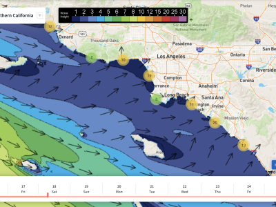
A temporary lull in westerly ground swell is also anticipated Friday through Sunday with waves averaging just 1 ft across all beaches this weekend. We could have slightly larger waves Friday but all-round waves will stay under 2 ft through the entire forecast period. Models show winds staying mostly calm through the weekend with a potential offshore breeze developing on Saturday.
Short to variable periods are predicted for Friday with longer periods becoming more widespread through the weekend. Sunday will most likely be the cleanest day. Aside from the slight rain chance on Saturday/Sunday, the overall weather looks nice for SoCal over the weekend. Mostly sunny skies are expected and highs will stay seasonably cool in the 60s.
Best Bets
-Sunday will most likely have the cleanest conditions with light winds and long periods. Sunday evening could end up having larger waves although right now we expect just 1-2ft heights.
-Saturday morning will have calm conditions with longer periods although waves remain small.
-All around the weather and surf conditions should be pretty consistent Friday through Sunday.
FRIDAY MORNING
Winds should be almost completely calm for Friday morning especially south of LA. We could see a light breeze from the south around Ventura and Santa Barbara but speeds will stay around 5 mph. The wind and overall weather for Friday morning shouldn’t be problematic in any way.
Temps will start out in the low-50s but the sun will warm us up throughout the day. As mentioned in the overview, waves will be small. Although Friday morning will have the largest waves of the weekend, they all around remain unimpressive with 1-2 ft heights for all beaches. Models show a chaotic period distribution ranging from 8 to 13 seconds from Santa Barbara down to San Diego.
FRIDAY AFTERNOON
The afternoon will really just be a continuation of the morning with no major changes expected. We could see winds pick up a little bit from the west by the evening but nothing too crazy is expected. Wave sizes diminish even further for the afternoon with almost everyone seeing 1 ft averages from the west.
Models still show periods being random around this timeframe with anywhere between 8 and 13 seconds possible. The overall weather is expected to be nice with no rain and highs in the low-60s for Santa Barbara and San Diego with mid-60s for LA. Clouds are possible to the north but we should stay sunny south of Ventura County.
SATURDAY MORNING
Light rain is possible but unlikely for Saturday morning. The day all around is expected to be sunny for all of SoCal. Temps will start off once again in the 50s similar to Friday, possibly a degree or two warmer in a few locations.
Waves don’t change much between Friday night and Saturday morning with 1 ft waves coming in from the west for all beaches. Winds remain calm to light offshore towards the north. We’ll start to see some consistency with period lengths around this time with 12 seconds anticipated for almost everyone.
SATURDAY EVENING
The European model is hinting at light rain for Saturday night but overall chances and rainfall amounts remain low. If anything, we’ll see clouds and a brief sprinkle or two. Winds may pick up out of the west for the afternoon but speeds stay under 10 mph.
Waves stay extremely small both nearshore and offshore. Widespread 1 ft and under heights are expected for all beaches. Periods will average around 12 seconds. Highs will warm into the mid to upper-60s making for a nice afternoon. All around this looks like a very calm day surf wise.
SUNDAY MORNING
Just like Saturday evening, Sunday morning will also have a slim possibility for light rain. More than likely, we will stay dry though. The morning will start off with temps in the mid-50s with winds staying under 5 mph from the west.
Again, waves won’t change much for Sunday. We’re still expecting 1 ft and under heights with 12 second periods from the west. Calm and relatively clean conditions are expected.
SUNDAY AFTERNOON
The ground swell may pick up a little further offshore by the afternoon but nearshore we still expect 1ft waves. It’s possible that 2 ft wave heights move in late in the evening but all around we expect very similar conditions to the rest of the weekend.
Winds will stay calm or under 5 mph from the west. The slim rain chance will extend into Sunday evening but most people will stay dry. Temps may be slightly cooler than Saturday with low to mid-60s, warmer towards LA and cooler to the north and south.