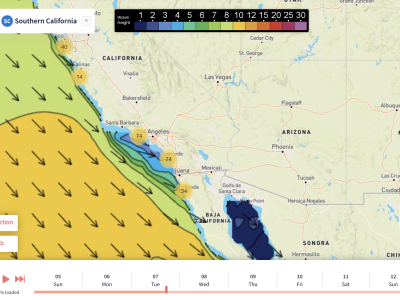
5.8.23 – The Southern Hemisphere swell that’s set to move in this weekend will fade Sunday night to leave Monday pretty quiet with 2-3 ft waves max. Surf should continue to stay small until winds pick up from the northwest as a lo approaches us on Tuesday. These winds pick up further offshore during the day on Monday but we’ll see them nearshore by Tuesday night.
A wind swell begins to develop thanks to our winds strengthening. The swell will gradually pick up in size during the day Tuesday and shift directions from the southwest to the northwest. Waves won’t pick up in size too much though. In fact, we’ll probably only see them increase in height by about 6 inches or so. It’s on Wednesday when we see waves grow significantly more.
Another round of Southern Hemisphere swell is scheduled to move in Wednesday afternoon and continue through Thursday. This will make for some of the greatest surf conditions so far in 2023 as we see 4 possibly even 5-foot heights from Huntington Beach down to Oceanside on Thursday. Periods look very nice as well with everyone seeing 16 seconds.
This week will be a breezy one but thankfully we’ll see periods, especially on Thursday, when the winds won’t be too bad. Tuesday and Wednesday look the windiest as the low moves in from the northwest. No rain is expected for this week with mostly sunny skies in the forecast for most days. Highs look to stay cool with upper-60s Monday and Tuesday and mid-60s Wednesday and Thursday.
Best Bets
- Thursday morning looks fantastic south of OC as the SH swell moves in and we see 4 ft waves with light winds.
- Thursday afternoon will have even larger waves although winds may pick up a little. 4-5 ft waves are expected south of OC
- Between Ventura and Santa Monica will also see some nice waves on Thursday with close to 4 ft expected throughout the day.
MONDAY
We’ll start the week off fairly quiet with lingering Southern Hemi swell from the weekend fading into Monday. 3-foot heights are expected south of OC down to San Diego. 1-2 foot waves are anticipated elsewhere with 3 foot waves potentially possible for Ventura County. Waves will pick up a few inches through the day as the wind swell starts to move in with winds picking up further offshore.
Nearshore winds should stay relatively light for the first half of the day but they will likely pick up by the evening. An onshore breeze is shown by models around 10-15 mph by 6 p.m. Despite this, periods still stay long with around 13 to 14 second averages. This will go down as our warmest day as LA reaches 70 degrees with upper-60s for San Diego and Santa Barbara.
TUESDAY
The wind swell continues to move in on Tuesday although nearshore winds during the morning hours don’t look too bad. We’ll see variable winds across the area with max speeds around 10 mph. Similar to Monday, winds will pick up gradually through the afternoon to where everyone is seeing a steady 10-20 mph onshore breeze by about 6 p.m.
Waves gradually pick up throughout the day along with the winds. The swell won’t increase in size by too much nearshore but offshore waves increase by several feet. Nearshore waves should stay around 3 ft south of OC and near VC with 1-2 ft waves around LA and Santa Barbara. Periods look slightly shorter (1-2 seconds) than that of Monday mostly due to the winds. Highs also look 1-2 degrees cooler.
WEDNESDAY
The morning starts out pretty similar to how Tuesday left off with steady northwest winds blowing onshore around 15 mph. The one difference is that we may see calmer wind speeds north of LA. The early morning swell doesn’t look a whole lot different compared to Tuesday although the Southern Hemi swell does start to move in during the afternoon.
Swell direction begins to shift to out of the SSW with heights increasing to near 4 ft south of OC. 2-3 ft waves are expected during the afternoon from Ventura to Santa Monica. Winds unfortunately stay somewhat strong around 10-15 mph coming onshore for the afternoon. Periods at least look really nice with the Southern Hemi swell bringing in 16 seconds.
THURSDAY
The best day by far looks to be Thursday as we the southwest ground swell continues to increase in size and the northwest winds and wind swell die down. The morning will start out with 4 ft waves from Huntington Beach down to Oceanside with 4–5-foot waves possible for San Diego south to the border. 3–4-foot waves are expected from Santa Monica to Ventura.
Through the day waves increase in size by close to a foot in the locations mentioned in the previous paragraphs. Periods stay nice all day with near 16 second averages and this also looks like our least windy day. The morning hours should stay calm with the afternoon hours seeing an onshore breeze pick up around 5-10 mph. Los Angeles has a high near 70 with San Diego and Santa Barbara making it into the mid-60s under sunshine! See The 10-Day Forecast