Overview
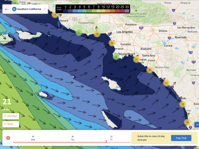
3/11/22 – 3/17/22: After a few days of small surf across the region, a bit bigger and better week of surf is ahead! There are a few different swells to talk about this week including a decent sized WNW groundswell. There will also be a few smaller NW swells as well as some fresh Southern Hemisphere swell. To start off the forecast into the weekend, we’ll see a little combo of NW and south swell. Size will gradually increase heading into the workweek as this mix of swells builds in. By Tuesday the 15th, we should start to see forerunners of our nice sized late season WNW groundswell. This energy is expected to build through that evening and eventually top out for most breaks Wednesday the 16th. This swell will then slowly drop off, and still show fun size to wrap up the forecast.
There are going to be some clean windows of surf through this week along with some fun swell. There may be a few mornings with slightly unfavorable conditions, so that is something to definitely keep an eye on as the workweek comes closer. Weather models have been bouncing around with conditions during the peak of the WNW swell on Wednesday the 16th, but things remain uncertain right now. Overall, conditions are looking more favorable through the weekend and for the start of the workweek. Temperatures are expected to be mild, with highs mostly in the high 60s for coastal areas. Things will remain dry, with no precipitation on the horizon.
Best Bets
– Multiple days of opportunity later in the weekend and into the workweek as our combo of NW and south swells show.
– Bigger size expected Tuesday the 15th, Wednesday the 16th, and Thursday the 17th as late season WNW groundswell shows.
– Most mornings should see clean conditions, but later in the week remains uncertain.
Day to Day Breakdown
Friday the 11th: 1-3 feet
The smallest day in the forecast. Only a minor mix of some trace NW swell and a small new south swell filling in. The morning will be clean, with offshore Santa Ana winds expected through the first half of the day. Onshore wind will pick up over the afternoon.
Saturday the 12th: 1-3 feet
Similar size to Friday, with a bit more south swell showing. Top summer spots could see a bit more size and consistency. The morning conditions are looking mostly light. A light west wind may start getting on it earlier than usual but shouldn’t ruin conditions at least for the morning.
Sunday the 13th: 2-4 feet
More size across the region as both NW energy and Southern Hemisphere swell are on the rise. Could be some opportunity for winter, summer, and combo breaks much of the day. One thing to note though is that the morning conditions don’t look ideal, a slight onshore breeze may be on it first thing. The afternoon isn’t looking any better, especially with a drained tide mid afternoon.
Monday the 14th: 3-4+ feet
A better morning looks to be in store. Southerly energy is expected to top out, and NW swell should hang in there. This is definitely a morning to target, as light winds with clean conditions are expected for the first half of the day. Most breaks across SoCal should see something fun with this mix of swells in the water.
Tuesday the 15th: 3-5+ feet (more size late for top winter breaks)
Another fun day of waves on the way. The morning may start off a tad slow for most areas as high tide bogs things out, and longer period WNW swell is on the rise. There will also be some south swell and leftover NW swell in the water, so targeting a high tide break that likes the mix of swells for the morning isn’t a bad call. More size will show later, but an onshore wind from the west is expected to blow through the afternoon. Still some opportunity nevertheless.
Wednesday the 16th: 4-6+ feet
The biggest day of surf for the week at least for winter swell magnets. Other breaks that don’t get this energy as well should be a bit smaller. There should still be some good opportunities up and down the coast this day for the majority of SoCal. Keep an eye on the local winds though, weather models have been bouncing around with lots of disagreement. Factor in the morning high tide too.
Thursday the 17th: 3-5+ feet
Size is expected to be on the downward trend as our late season WNW groundswell begins to decline. There should still be lots of this WNW energy across the region though, especially as the period drops off a few seconds letting more unexposed breaks get their fair share of the swell. Another south swell is expected to show this day too, which could add some size and consistency to those summer/combo breaks. Definitely looking like a fun day if we can get the winds to cooperate.
Long Range Forecast
We have another WNW swell expected that will soon be in route to SoCal that has exceeded my expectations. The NPAC is definitely not over for the winter, and we will probably see a few more fun sized pulses from there this month. It’s also nice to see the South Pacific waking up right on track as it usually does for this time of year. Expect more modest to fun sized pulses of south swell this month. So definitely some surf to look forward to these next few weeks!
Not a whole lot to report about precipitation though. This winter continues to be an extremely dry one, not only for SoCal but for the entire state of California. In fact, according to NOAA’s recent data for the month of January and February, this period was the driest on record for much of California in at least 127 years. Unfortunately this is not great news for our long term drought situation as we soon enter our dry season.
– Jax Richards @jax6street
If you’d like to receive these day by day forecasts every week, sign up for our newsletter