If you think we’re done with the rain, you’re wrong. Another low/storm-system is set to arrive Monday night and last through the day on Wednesday providing 1-3 inches of additional rainfall across SoCal. Models so far are showing Thursday as rain-free but there’s still a possibility that we see precipitation extend into Thursday.
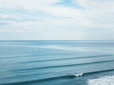
As far as surf goes, the weekend has so far been pretty boring with small waist-high waves. Monday will mostly be a continuation of Saturday and Sunday but we will see a ground swell start to move in from the west overnight and into Tuesday morning. The ground swell really picks up on Wednesday but then tapers off slightly for Thursday. If Thursday stays dry, it could be a pretty good time to surf.
This week could have some pretty windy periods as well, particularly Tuesday afternoon as we get closer to the center of the low-pressure system that’s set to bring all the rain. Other than that, Monday through Wednesday should be decently windy with speeds over 10 mph. Thursday should be are nicest day with calm conditions nearshore.
We will likely reach 60 degrees in most places before it starts raining Monday evening. Tuesday and Wednesday’s highs are going to be chilly due to the rain, most places stay in the mid to upper-50s. Finally, the sun is set to come for Thursday and that should warm us up into the 60s areawide. Thursday is indisputably looking like are best surf day.
Long-term we do have some changes. The jet stream is currently sitting pretty far south with a zonal direction i.e., flowing flat from west to east. We’ll begin to see the jet transition back into the pattern from earlier in the winter with a more northwest to southeast direction. This will change storm and swell paths as in the future we will see storms/swell move in from the northwest instead of the west.
Best Bets
-Thursday morning have the largest waves when it also will be dry. This should be the best time to surf given bacteria contamination from rain runoff isn’t bad.
-Thursday afternoon will also be pretty nice although the ground swell will decrease in size. Winds could also pick up slightly but all around nice surf weather is anticipated.
-Monday morning looks like it should be dry north of LA although it will be somewhat windy and waves will average 1-2 ft.
MONDAY
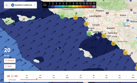
The first half of Monday actually looks alright. The rain should hold off until the evening and that means sunny skies and temps in the 60s especially north of LA. The rain could begin a little earlier further south close to San Diego. There won’t be much in terms of swell. Waves will average 1-2 feet across all beaches for most of the day.
Periods will vary depending on location but the vast majority of places should see 11 second lengths. Isolated areas could see much shorter period lengths. The swell may pick up a little by the evening, especially offshore. This is about when we expect the rain to become widespread so surfing isn’t recommended for the evening. Winds will average 10 mph from the west all day.
TUESDAY
Rain is expected to be falling all day on Tuesday. Winds also really pick up out of the south during the afternoon as the center of the low moves onshore. 30+ mph winds are possible. This looks like a nasty day all around. Highs will stay in the 50s for almost everyone making for a chilly and rotten day.
The west ground swell will continue to move in and strengthen during the day. Unfortunately surfing won’t be possible due to the rain. Closer to 2-3 ft waves are anticipated by nightfall with some pretty short periods. Thankfully we will see the ground swell continue to strengthen Wednesday to provide for a nice surf day Thursday.
WEDNESDAY
More than likely, it will still be raining on Wednesday although the heaviest of the rain will come Tuesday. Still, Wednesday looks like a poor day to surf or do anything outdoors. Temps will max out in the 50s similar to Tuesday making for another chilly day.
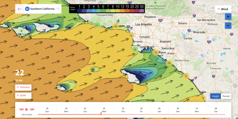
Winds will calm down significantly between Tuesday and Wednesday night. By nightfall closer to 10 mph winds from the west, an indication of calm weather ahead. We should also have some impressive ground swell by the evening with 10 ft waves near San Diego and anywhere from 4 to 8 ft waves expected for other west facing beaches.
THURSDAY
The rain finally ends for Thursday making for our first good surf day this week. The ground swell from Wednesday will stick around but weaken slightly throughout the day. 4-7 ft waves are expected to start the morning off coming in from the west. By the evening waves will decrease to about 3-5 ft height for west facing beaches.
Periods will stay between 11 and 12 seconds all day making far clean and well-formed waves. On top of this, winds should be almost calm nearshore for most of the day Thursday, especially in the morning. Winds may pick up slightly for the afternoon out of the west. Temps will reach the low-60s everywhere with sunny skies making for the best surf day by far.