Overview 2.26 – 3.2 – Whether you like the rain or not, get ready for some more because we have a wet week ahead. On the heels of this latest system is another low and that will kick up rain chances once again starting on Monday and lasting till at least Wednesday. Thankfully, this secondary round of rain won’t be as intense as our last but it will be enough to keep people indoors and prevent us from warming above 60 degrees until Thursday afternoon.
This low will stay to the north of us unlike the last and that’s part of the reason why we wont see as much rain. This system will be slower moving however, and that’s why we expect rain over multiple days in SoCal. Winds will also be lighter for most of this week until Wednesday when we see winds pick up from the NW around 30-35 mph.
By Thursday, the winds will die down completely for the most part which is perfect timing because that’s when we expect the rain to end and the sun to come out. Temps will also finally warm up to the low-60s for the afternoon which will be the warmest all week.
As far as surf goes, we are looking at 1-2 ft waves for Thursday which will be our best day. Waves stay relatively small all week even with the high winds on Wednesday. We start Monday off with a 1-2 ft wind swell and gradually see wind/ground swell pick up through the day and peak by Tuesday afternoon. From there, waves gradually decrease in size despite the winds on Wednesday.
Best Bets
-Thursday will be the best day by a long shot as the sun finally comes out. Waves will stay small (1-2 ft) but at least it will be warmer with little wind and period lengths will average 15 seconds.
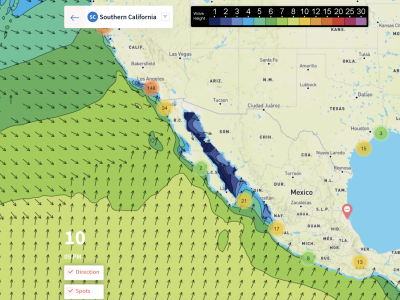
-Tuesday Morning near San Diego may be promising as long as it doesn’t rain. 4-5ft waves will be possible as a ground swell moves in with winds on the lighter side toward SD.
-Monday morning would be the third best day to hit the waves as it could be dry for Orange County southward. Winds may be light enough to surf in but waves will be small (1-2 ft).
 See the 10-Day Forecast
MONDAY
We will start out the day on Monday with light onshore winds north of LA and calm conditions to the south. Waves will be small in the range of 1-2 ft up and down the coast. Winds stay relatively light through the morning but will pick up by the afternoon to were everyone is seeing an onshore breeze around 10 mph.
The wind swell will should pick up because of increasing wind but still stay small. 4 ft waves are expected near San Diego with everyone else expecting 1-3 ft. We may be dry for a little while in the morning mainly towards the south but, by the afternoon on/off rain, and cold temperatures will be widespread.
TUESDAY
A lot of the same conditions will continue from Monday into Tuesday. That includes the light rain, cold temps, and all-around poor conditions. Everyone will start the day off in the 40s and be in the 50s by the late afternoon. Rain will be on and off to the north while the south may be dry enough to surf for a while in the Morning. Rain will become increasingly widespread by the afternoon however.
Winds will stay light through the morning out of the northwest at around 10 mph. We’ll see winds pick up for the afternoon with 15 mph sustained speeds out of the west. A dominate ground swell will be in place through the day near San Diego out of the west. Surfing weather may be possible near the border just briefly in the morning if it doesn’t rain as a 4-5 ft ground swell is expected.
WEDNESDAY
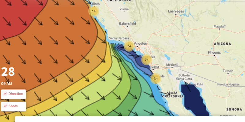
Wednesday morning, we will really see those northwest winds pick up. 30+ mph winds are expected area wide by the afternoon. Models are showing that this will also be our wettest day with widespread moderate rainfall expected all day throughout SoCal. Temps will also range from 40-55 degrees throughout the day.
Overall, Wednesday is probably going to be our worst day so surfing is not recommended anywhere on this day. On top of this, waves don’t look that impressive considering the strength of the winds by the afternoon with a 3-4 ft wind swell expected on average.
THURSDAY
Finally, we will start to see the rain exit the area for Thursday. We could see some lingering rain in the morning down to the south but by the afternoon everyone will see sunny skies and temps in the low-60s. Winds will start out from the NW for the morning but then we will see a transition to a light offshore breeze by the afternoon. We could even see winds die down completely.
Waves will, however, be weak throughout the day. They will be larger in the morning as the winds will be stronger but not big by any means. 3 ft heights are the max expected all day which should occur in the morning towards the Mexican border. By the afternoon everyone will have 1-2 ft waves with periods averaging around 15 seconds except near Santa Barbara where there could be much shorter periods.