Overview:
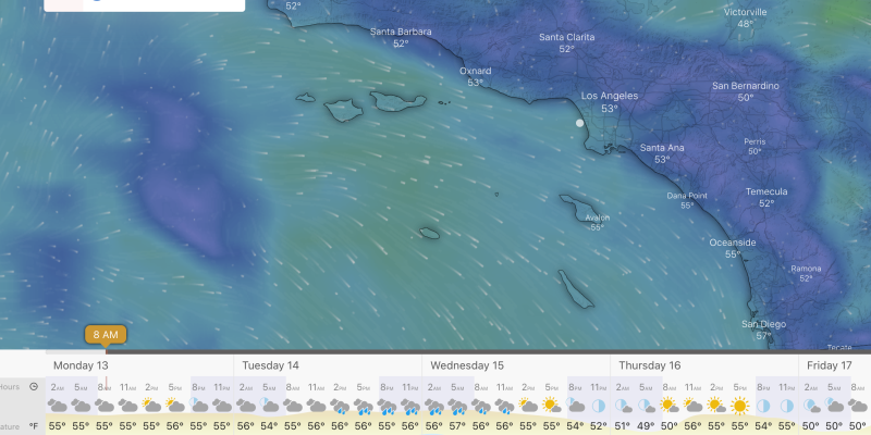
3.11..23 – 3.16.22: The west ground swell that’s been in place through the weekend will continue into Monday before we see a brief lull in the waves and an increased chance of rain for Tuesday morning. The newly formed pattern out in the Pacific will continue to bring us additional rounds of ground swell from the west along with rain mixed in.
Unfortunately, this next atmospheric river that’s set to arrive on Tuesday looks like it will dump inches of rain in our area. Additional feet of snow are possible across higher elevations including the Sierra Nevada, San Bernadino, and San Gabriel Mountains. This is the absolute last thing needed in those locations as homes and businesses are already buried in snow.
Luckily, this rain event should be fairly short-lived as the precipitation wraps up by Wednesday evening. Waves die down during the day on Tuesday but will see the ground swell pick back up by Wednesday morning. The ground swell will, however, be overrun by a dominate wind swell on Wednesday as winds become strong from the northwest.
Thursday looks pretty calm as rain exits the area and winds die down completely across SoCal. With the sun out, temps will reach the mid-60s making for a cool but pleasant surf day. Waves around this period will be small compared to the rest of the week. 2-3 ft waves are expected on average but with calm conditions it might turn out to be a good day for beginners.
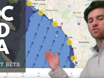
Best Bets
-Monday morning will be the best time to surf with a strong ground swell in place from the west. Light winds and sunny skies will make for a beautiful morning no matter where you are in SoCal.
-Monday afternoon looks almost as nice as the morning but wave heights will decrease a little. This still should be an excellent time to surf.
-Thursday comes in third place as surfing is essentially deemed impossible Tuesday and Wednesday. Light winds, sunny skies, and small but clean waves will make for a decent surf opportunity Thursday.
MONDAY
Monday basically looks like a continuation of Sunday at this point with close to a 4ft ground swell expected along west facing beaches. The largest waves will be located near the border where closer to 5 ft heights are anticipated. Winds will be calm throughout most of the day with overall nice weather expected across SoCal. Low to mid-60s during the afternoon with mostly sunny skies will make for an almost perfect day.
Periods remain decent as widespread 11 second lengths are expected. Isolated pockets of longer period lengths are possible although forecasting their precise locations is difficult. Wave heights may decrease slightly throughout the day with closer to a 3 ft average expected along west faces by sundown. South facing beaches will stay between 1-2 ft all day.
TUESDAY
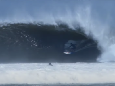
If you can, go out on Monday, because Tuesday and Wednesday look really ugly. It’s possible that you may have an opportunity to surf in the morning but, by the afternoon everyone will be seeing rain for Tuesday. It’s a shame that it’ll be raining because we expect some of the largest waves of 2023 to occur during this time. We could see 10 ft waves near San Diego Tuesday evening.
These waves will start out as ground swell with little wind expected for most of Tuesday. By nightfall we’ll see winds pick up from the northwest as we get to the backside of the low-pressure system bringing all the rain. As this occurs, we should gradually see the rain taper off. Even with the rain, temps should still climb into the 60s for Tuesday.
WEDNESDAY
Light on and off rain is possible across the area to start the morning off although most of the heavy stuff should be over with by this point. Rain won’t be the main story for Wednesday, instead that title will be reserved for the wind. As we move to the backside of the low, our winds will pick up dramatically out of the northwest. By the morning, 30 mph winds are possible offshore while nearshore winds will be closer to 15-20 mph.
An impressive wind swell will develop to replace the diminishing ground swell from Tuesday. West facing beaches will see on average 5-6 heights while 8-10 ft waves are possible near the Mexican border. Winds will gradually decrease through the afternoon and become calm overnight with the wind swell behaving in a similar fashion with waves decreasing gradually.
THURSDAY
Calm winds, sunshine, and less chaos on the water will make Thursday the second best day to surf this week after Monday. Models are in alignment with rain being out of here by Wednesday afternoon so I think it’s safe to say that Thursday will be dry and sunny. Mid-60s are expected during the afternoon making for a beautiful early spring day.
In addition to sunny skies, calm to variable winds are expected through the day making for great surfing weather. The one caveat is that there won’t be too much energy on the water during this time period. We’ll see 2 ft waves on average during the morning hours while wave heights diminish further by the afternoon. West facing beaches will all around have larger waves than south facing beaches.