Overview
1/7/22-1/13/22: Finally a good week of waves on the way to Southern California! After a quick start this fall in the North Pacific, things went fairly quiet for most of November and December. High pressure that’s been dominating the NPAC has weakened (for now at least), and multiple storms are expected to send solid WNW groundswell to the entire West Coast.
To start out the forecast, over the weekend will see some fun waves from smaller to medium sized WNW swell. Things really get going over the workweek as our bigger and more prolonged WNW swell peaks. The biggest days will be Tuesday the 11th and Wednesday the 12th, but good sized surf will continue all the way into next week’s forecast. This bigger WNW will have more west (~280°) than most groundswells we see, so lots of breaks are going to get waves. The swell will start off with a longer period, so the back half of the swell will be when these waves get into more areas as the swell period drops.
Mostly dry weather will continue into January, with not much precipitation in store for at least through the middle of the month. A few cut off lows have the chance of delivering the region light precipitation, but as of right now it’s not looking like much. Due to a little bit more spread than usual between the global weather models, confidence is slightly lower for conditions through the week. The first half of the forecast is looking light overall, with the chance of a few mornings seeing a slight texture. The good news is that during the back half of the forecast, morning conditions look to improve. Overall, winds don’t look like a major issue this week, but make sure you keep an eye on the conditions as things will change in the coming days.
Best Bets
– Biggest and best days in the forecast will be Tuesday the 11th, Wednesday the 12th, and Thursday the 13th as solid WNW peaks.
– The weekend will still be fun as smaller WNW peaks.
– Target the mornings for the best window each day.
Subscribe to see the 10 Day forecast
Day to Day Breakdown
Friday the 7th: 2-3+ feet
Smallest day in the forecast. Even though it’ll be on the small side, a mix of new and old WNW swells will result in fun surf for the winter time magnets. The morning may start off with a very light onshore wind, but will still be mostly clean. Light wind expected all day and the marine layer looks to move in .
Saturday the 8th: 3-4+ feet
A fun little mix of leftover WNW and new WNW swell. Most of the region looks to be clean, but areas down south from OC to San Diego may be dealing with a slight texture due to light south wind. Still worth a look throughout the day as winds stay on the lighter side from the south. A deeper marine layer looks likely too.
Sunday the 9th: 3-4+ feet
Similar size to Saturday as that newer WNW swell holds fairly steady. Morning conditions are looking pretty clean across the board, so that will be a nice time to get in the water. Again, afternoon onshores don’t look too strong so an afternoon session may be worth it.
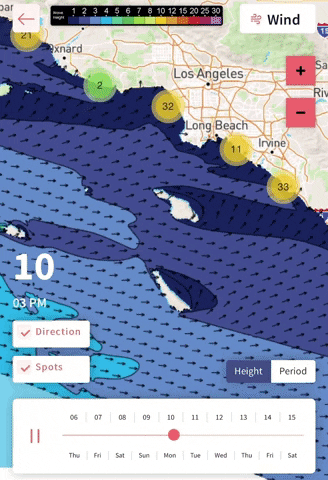
Monday the 10th: 2-4 feet
WNW swell trends down, but the bigger WNW will show late. The new bigger swell won’t be adding too much size to what’s already in the water, but it may show bigger sets for areas farthest north in Ventura and SB before dark. Models are somewhat diverged on conditions, as a weak trough enters the region along with a slight chance of showers. Still looks mostly clean.
Tuesday the 11th: 4-6+ feet (larger sets possible later in the day)
One of the best days for winter time spots in a long time. Good sized WNW will build to a peak, showing best size for most spots in the afternoon. The morning will be a good time to target the longer period focal points as the energy comes in at about 16-17s. The morning conditions are looking favorable at the moment, with light offshore flow. A light onshore breeze looks to pick up in the afternoon.
Wednesday the 12th: 4-6+ feet (select winter breaks will see larger sets)
Another day of pumping good surf. Good sized WNW holds solid all day. Winter time focal points will see the most size, but as the period drops to 14-15s, other spots will begin to see some fun surf. As of right now, the morning winds are looking fairly light. That will be the best window of the day, but don’t rule out an afternoon session as onshores shouldn’t blow things out.
Thursday the 13th: 3-5+ feet
Fun run of surf continues. WNW will be on the downward trend, but will still be showing really fun waves across the region. Too early to tell on local winds, but they may trend unfavorably as another trough approaches the region. Slight chance of showers. Definitely a day worth watching.
Long Range Forecast
Finally some real groundswell approaching Southern California this upcoming week, and things may continue that way in the near future. High pressure is finally breaking down in the North Pacific, which is great news for surfers on the west coast. This is partly because of the active phase of the madden julian oscillation (MJO) moving east enough and helping feed the jetstream into much of the North Pacific. These next few weeks are probably the best time to score waves from the NPAC this year, because the pattern into February isn’t looking as favorable as the one we are entering right now. Hope everyone gets some fun waves!
– Jax Richards @jax6street
Subscribe
We can email you the weekly forecast every week! Enter your info below.
View previous campaigns.