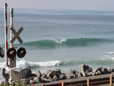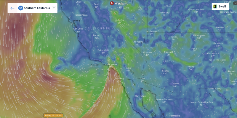
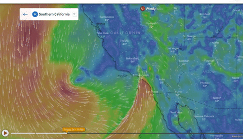
Overview (2.24 – 2.26) – Get ready because we have a lot of rain headed our way! The high-pressure system that I mentioned in the previous discussion is still located far out in the Pacific making for just enough room to let the jet stream position itself along the West Coast. With this setup in place, another low will make its way down the coast and into our area by Friday Morning.
This low will behave a bit differently in comparison to the previous few we’ve seen. Instead of taking a more easterly path like we usually see, this system is going to stay offshore and move further south before it moves onshore near the Mexican Border. Because of this unusual trajectory, we can except a whole lot of wind, waves, and rain (especially rain).
The rain will begin around Santa Barbara before the sun rises on Friday morning. A very strong band of precipitation will form up north and head southeast through the day on Friday. Rain will likely begin sometime around mid-morning but possibly sooner for LA and San Diego.
We will see on and off intense rain through the region for the better part of the day on Saturday before we finally start to see some clearing by Sunday. Light rain may still be possible in some locations for Sunday morning but in general everything should be heading on its way out to the east by this period.
With all the rain, we will also see strong WSW winds and wind swell through the weekend. Due to all of the rain, possible thunderstorms, and wind, surfacing is highly discouraged until Sunday when we should start to see calmer conditions. Subscribe to see the 10-Day Forecasts
Best Bets
- Sunday afternoon will likely have the best conditions with rain finally exiting and wind dying down. Waves look weak though and temps will still be cold.
- Saturday afternoon could possibly have nice conditions from Venice Beach to Ventura with ~4 ft swells and weaker winds. This opportunity could however be ruined by rain.
- Sunday morning may have somewhat ideal conditions as rain starts to exit the region. However, it may still be kind of windy and waves don’t look too big.
FRIDAY MORNING
Heavy rain, possibly thunderstorms, will be likely to start the morning off across much of the area especially north of LA. There could be a few locations to the south that may be rain-free early in the morning but by noon everyone will have rain. Winds won’t be too bad to start the morning off, but they will gradually pick up out of the south through the day.
With the winds, will come a wind swell which will couple on with a very weak WSW groundswell. On average, we can expect 20+ mph winds out of the south throughout the morning up and down the coast. The swell will be around 3-4 ft for west facing beaches with 1-3 ft swell for south faces. There may be a brief chance to surf near the San Diego early in the morning but conditions after 9 am look unpromising.
FRIDAY EVENING
Poor conditions are expected to persist through the afternoon. Winds will become even stronger (near 30 mph) from out of the south with a transition to west winds by nightfall towards Santa Barbara. While wind speeds pick up, the wind swell will grow by about 1-2 ft by nightfall.
As far as precipitation is concerned, it looks like rain will intensify and spread to encompass the entire area from Santa Barbara down to the border. Surfing is not recommended anywhere on Friday night due to rain and hazardous conditions.
SATURDAY MORNING
The bulk of the rain will shift to the south and east by Saturday morning with on and off rain expected north of LA and consistent, widespread rain expected to the south. Winds will be much calmer by this point out of the southwest around 10 mph up and down the coast. Winds will be picking up through the afternoon unfortunately.
The waves will be slightly smaller for the morning as winds die down but still large enough to surf if we end up getting a break in the rain. The best chance of this happening would be near Santa Barbara and Ventura where up to a 4 ft wind swell is possible. Conditions still look very poor area wide with air temps in the 40s and periods ranging from 6-10 seconds.
SATURDAY AFTERNOON
Sadly, conditions still look to be very poor for surfing area wide by Saturday afternoon. The rain should be on its way out by this time but lingering on and off light rain still looks probable especially to the south. Winds will also be stronger around this timeframe with most locations experiencing at least 10-15 mph winds. Winds will be stronger and onshore south of Orange County but areas to the north will likely see easterly winds which could be weaker.
From Venice Beach up to Ventura we could see some better surf conditions as a 4 ft ground swell moves in and winds stay weak for the afternoon in this area. Hopefully the rain doesn’t ruin your chance to surf in this area. Unfortunately, periods look short with an average of 7 seconds all along the coast.
SUNDAY MORNING
This will by far be the best day of surfing. Models have come to somewhat of an agreement that the rain should be over with by mid-morning on Sunday although lingering rain still could be possible. Aside from that, the winds will be calmer and the sun should finally come out.
We could see gusty conditions at first with winds out of the northwest around 10 mph but as we go throughout the day they will die down. As the winds come down, we will also see wave heights diminish. In fact, as we start the day, we expect just 2-3 ft waves for west facing beaches and 1-2 ft waves for south faces.
SUNDAY AFTERNOON
Conditions will gradually improve throughout the day but I still wouldn’t call them good. High temperatures will be cold in the mid-50s, and the swell will stay between 1-2 ft for the afternoon across the forecast area. At least periods will start to lengthen towards the end of the day with 13-14 seconds expected to the south while the north will still have periods under 10 seconds.
Winds will also be calmer towards the south with an onshore breeze under 10 mph expected for areas south of Ventura. Santa Barbara could see stronger winds around 15+ mph out of the west. Sunday afternoon will be the best time to surf this weekend but as implied by the above forecast details, conditions will by no means be good.