Overview: Well, this weekend was pretty active with some large ground and wind swell. And as of now, it appears we will continue to see some impressive waves through this coming week. The swell from this weekend has faded as the system that brought it departs but it looks like another system will bring an additional round of ground swell Monday which will last through most of the week.
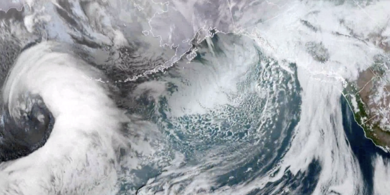
There’s another powerful low-pressure system sitting up in the Gulf of Alaska, similar to the last one that brought the most recent swell this past weekend. This system will take an almost identical trajectory as the last which means we are forecasted to see very similar conditions this coming week compared to this past weekend.
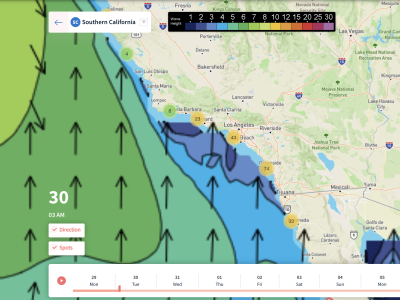
All around we should see the ground swell pick up Monday night and peak during the day Tuesday. Unfortunately, another cold front associated with this system will make its way down the coast and impact us by Tuesday morning. Winds will be strong from the NW beginning around noon on Tuesday and that will last until about Wednesday morning before they really start to calm down. With the wind, comes a strong wind swell that should create some massive waves on Tuesday.
As far as air temperatures go, Monday should be nice although it will be a little chilly with highs in the low to mid-60s across the area. The front on Tuesday will do some slight damage to our highs taking them down 2-3 degrees but the real impacts will be to our lows as upper-30s and low-40s are expected Wednesday and Thursday mornings. Tuesday could be a little cloudy especially to the north as the front arrives but other than that we are expecting sunshine for the rest of the week!
Video Breakdown
Best Bets
- Monday afternoon and evening looks awesome across the entire area as the ground swell moves in before the cold front and winds stay relatively calm especially north of LA.
- Midday on Wednesday looks pretty nice as well with winds finally calming down and shifting to offshore with 3-4 ft swells on average expected across west faces.
- You could catch some huge waves Tuesday evening if you wanted although the winds will still be pretty bad. Oceanside southward will have 5-7ft waves but winds will be onshore around 15-20 mph.
Day to Day Breakdown
MONDAY
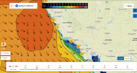
Honestly, this looks like the best day to go surfing throughout the entire forecast period. Winds will start out at under 10 mph from the SE for everyone except for maybe Venice Beach which could have slightly stronger Santa Ana winds. Winds will die down almost completely for everyone north of LA through the afternoon while areas south will see winds pick up a little at around 10-15 mph from the south blowing parallel to the beach.
The ground swell will start off pretty weak early in the day but progressively grow through the morning. By noon we’re looking at a 4ft ground swell near Oxnard and west facing beaches to the north with 6 ft swells near San Diego. Periods will slightly decrease through the day but stay nice within the range of 12-16 seconds across the area.
TUESDAY
This is where things get interesting. The front will have made its way south of San Diego by sunrise on Tuesday although winds may not be too bad in some locations for the morning. Between Oxnard and OC the winds will be on the lighter side, below 10 mph for the morning, but by the afternoon almost everyone will see winds pick up to 15-25 mph from the NW making surfing difficult.
Waves will start out in the morning around 4 ft for west facing beaches and 2-3ft for south faces north of LA with 4-6ft swells expected south of OC. There could be a few pockets of decent surfing conditions in the morning where winds are calmer. Wind swell picks up through the afternoon with decreasing ground swell as waves stay of constant size throughout the day. Periods will stay around 12-13 seconds all day with highs in the low-60s.
WEDNESDAY
Morning temps will be cold with upper-30s expected north and low-40s to the south. Luckily winds will be calmer by Wednesday morning with everyone experiencing an offshore wind around 5-10 mph. Waves look decent with a 2-4ft ground swell expected across the coast through midday with higher heights on west facing beaches. Around noon looks great as we warm into the mid-50s area wide and periods stay between 13 and 14 seconds all day.
Everyone will get into the low-60s by the afternoon with the exception of Santa Barbara which will stay in the upper-50s with sunshine across the board. The ground swell will weaken even further and winds look like they could pick up a little from the NW so before 2 p.m. will definitely be the best time to hit the waves.
THURSDAY
Light Santa Ana winds return for everyone by Thursday morning with stronger winds around Oxnard at 10+ mph. These winds will warm the entire area up into the mid-60s by the afternoon despite having another cold morning similar to Wednesday. This would be a good day to surf but sadly waves won’t be big at all. We’re looking at 3ft swells max for San Diego while everyone else has 1-2 ft swells.
Winds will die down through the day and even become variable through the afternoon. Unfortunately, the ground swell only weakens and by sundown we are expecting just 1-2 ft swells for almost everyone. Periods will be highly variable by this point but on average we expect 12-13 seconds. At least the afternoon will be a good day for beginners to try out surfing.
Subscribe to unlock the 10-Day Forecasts for California, Hawaii, etc