Overview
12.10.21 – 12.16.21 – Not the best week of waves on the way for this forecast, but a much needed storm is on track for the beginning of the workweek. This storm will deliver some good sized swell, but the conditions will be pretty messy and the water quality will most likely be pretty poor for most areas.
Before our significant storm system due for the workweek, we will see leftover NW windswell Friday the 10th and linger into that weekend. This is due to the weaker storm system we saw move through the region Thursday the 9th. The surf will drop off in size until Tuesday the 14th as the major storm system approaches the coast. Through the day Tuesday we will see a mix of building short period south windswell and a decent sized mid-period WNW swell. Then on Wednesday the 15th, the south windwell will drop off very quickly, and the leftover WNW groundswell will show good size early. The winds may clean up for Wednesday, but water quality could be pretty poor.
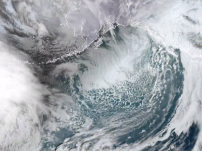
The main story this week is the significant storm system expected to impact the region Tuesday the 14th. This is looking like one of the stronger storms we’ve seen in the past year or so in terms of precipitation. Through the weekend things will remain dry with favorable conditions each morning. Starting Monday the 13th we’ll begin to see conditions deteriorate. We won’t see the rain move in until later in the day Monday, and that will only be for areas up north near Ventura and Santa Barbara. Tuesday will be the day we see the core of the front move through the region. Areas farther north can expect anywhere between 1-3 inches of rain, while farther south down towards OC and San Diego can expect around 1-1.5 inches. Gusty south winds are expected, switching west after the front passes through. Conditions look to improve for Wednesday and Thursday, but for how bad the water quality could be it may not be worth it. It will all depend on your location.
Best Bets
– Get on it Friday the 10th and into the weekend while conditions are favorable.
– Surf will be biggest Tuesday the 14th but conditions will be blown out along with rain.
– Conditions improve with leftover swell for Wednesday and Thursday, but water quality will most likely be poor due to heavy rain.
Day to Day Breakdown
Friday the 10th: 2-4 feet
One of the better days in the week. There will be some fun windswell in the water, showing the best size for the morning. Could be enough south in the water for a few peaks too. Morning winds will be mostly favorable with the possibility of textured southeast wind down towards OC. Afternoon winds should stay on the lighter side with opportunity for fun waves all day.
Saturday the 11th: 2-3 feet
Shaping up to be a fun little morning. A small mix of south swell and leftover windswell will be enough for a few peaks across the region. The morning will see light offshore wind, followed by just a weak onshore breeze.
Sunday the 12th: 2-3 feet
Slightly smaller than Saturday, but there should still be a few peaks lingering for those swell magnets. Last day of favorable morning conditions for at least a few days.
Monday the 13th: 2-4 feet
Smallest size early as new swell builds late, but it won’t really matter because conditions will be pretty poor all day. Probably a good call to take the day off.
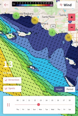
Tuesday the 14th: 4-6+ feet
Blown out all day with periods of rain. Gusty south wind switching west after the front moves through. The two main swells in the water will be localized south windswell and WNW groundswell from the same storm system. The peak of the rain will move in around midday for most of SoCal. Protected breaks in the afternoon may have a window, but keep an eye on your local water quality.
Wednesday the 15th: 3-5+ feet
South windswell drops off quickly, but WNW groundswell will show good size especially for the first half of the day. Although winds may trend more favorable in the morning, things will most likely be pretty jumbled. The storm will exit the region and clear skies will return.
Thursday the 16th: 2-4 feet
Leftover WNW swell should show a few fun waves across the region. Right now the morning winds are looking favorable, but things are still too far out to be sure. Some models are even showing another storm system approaching the region. Too much uncertainty to say right now.
Long Range Forecast
It’s pretty good news to see these storms making it through the region this week. Our state desperately needs this rain and mountain snow. This more active storm pattern looks to continue through December, which is great in terms of our current drought situation across the state, but not the best for surf.
Although it’s not going to be flat, no major swells are on the horizon besides the one peaking this Tuesday. The last few weeks of December may be our best shot of seeing something significant until we enter the new year.
– Jax Richards @jax6street
If you’d like to receive these day by day forecasts every week, sign up for our newsletter