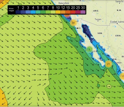
Overview: (February 10 – 12) After a fairly calm week, this weekend is shaping up to be pretty active across SoCal. Models have come into agreement that a system that’s currently producing 25-30’ waves will make its way down the Pacific Coast and give us some pretty nice ground swell this weekend.
Right now, the storm system that’s producing these waves is still way off to the northwest close to the Gulf of Alaska. Over the next 24-48 hours the system will continue its westward track but a piece of energy will break off and head south down the coast to give us some pretty huge ground swell beginning Friday.
Unfortunately, with the ground swell will also come strong northwesterly winds by Saturday Morning. This will be part of a cold front that could produce some showers across the area and colder conditions for everyone. It appears that the front should pass through late Friday night into early Saturday morning with showers possible during the day Saturday. Temps will fall by 15-20 degrees behind the front with the chance for rain slim but still significant enough to be worth mentioning.
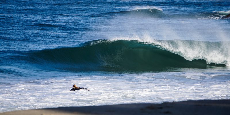
Winds will gradually die down throughout the day Saturday making the evening a better time to go surfing. Light offshore Santa Ana winds return by Sunday Morning which will help temps climb by 5 degrees for Sunday Afternoon with sunny conditions. Unfortunately, the ground swell will have dissipated by Sunday Morning so waves won’t be nearly as big. (Featured Image courtesy @jamesferrell_
Best Bets
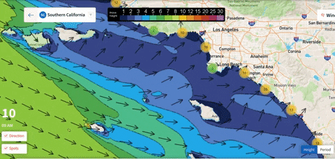
- Friday afternoon looks to be a very solid day with light winds, sunny skies, and a 4-6 ft NW ground swell from San Diego down to the Mexican Border. Conditions won’t be as good north of LA as swells won’t be as high and it will be windier but it still looks like decent surfing is possible.
- Saturday morning will see the largest waves as swells could be 8 ft for San Diego with 4-6 ft swells expected for west facing beaches further north. Unfortunately, onshore winds and cold conditions will make the day harder to enjoy.
- Sunday Morning looks nice as winds will have died down but a 2-4 ft ground swell will still be present for west facing beaches especially between Orange County and San Diego. Swell will gradually die down throughout the day so you want to get out there before noon.
Day to Day
FRIDAY MORNING
Friday is looking pretty nice so far with waves expected to gradually pick up throughout the day. For the morning we’re expecting 2-3 ft ground swells from the northwest for everyone except San Diego where the swells will be 4-6 ft. Period lengths will be very nice for everyone with 13-14 seconds expected almost everywhere, Santa Monica down to Huntington beach may have periods as long as 16 seconds.
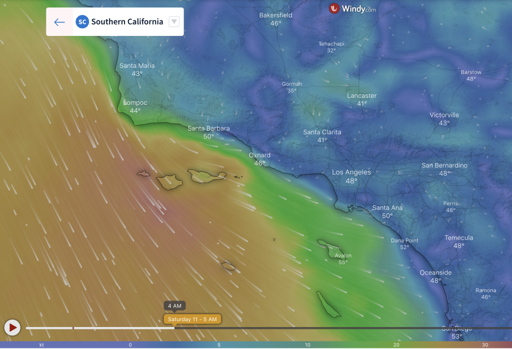
A light offshore wind is expected across the entire coast during the morning hours except near from Oxnard down to LA where the Santa Ana winds could pick up to around 15 mph. These winds will help temperatures warm up though as we start off in the low-50s but then get up into the mid-70s area wide under mostly sunny skies by the afternoon. Northern areas will be slightly cooler with low-70s expected for Santa Barbara.
FRIDAY AFTERNOON
By the afternoon the period lengths will slightly decrease to where everyone is experiencing 13 second periods. This is about the time when the NW ground swell really kicks in. 3-4 ft ground swell is expected after 3 pm for west facing beaches with areas near San Diego and Oxnard seeing ground swell as high as 5-6ft. South facing beaches will maintain 2-3 ft swells.
Winds during the afternoon die down almost completely from Oxnard southward from 2pm to 4pm but then they start to transition out of the NW as the front approaches. Winds by sundown will be about 10 mph from the NNW across the entire coastline. As mentioned earlier, highs temps will be very nice in the mid-70s for almost everyone.
SATURDAY MORNING
By Saturday morning the winds will have really picked up with the arrival of the front. NNW around 15-20 mph are expected everywhere north of Orange County. Winds will hold off to the south through the morning hours at around 5-10 mph from the NNW. Waves will be huge during the morning with a WNW wind swell combining with the already existing ground swell. San Diego could see waves as high as 8 ft. Most west facing locations further north will stay between the 4-6ft range.
Periods will come down to about 11-12 seconds for west facing beaches by Saturday morning. South facing beaches should have periods between 12-13 seconds. The weather doesn’t look to be nearly as nice Saturday as it did Friday thanks to the front. Temps will be in the 40s and 50s near Santa Barbara with a chance for rain through the morning while areas south will likely stay dry but temps still stay chilly in the low 50s through a lot of the morning.
SATURDAY AFTERNOON
Highs by Saturday afternoon look to stay on the chilly side with everyone topping out at right around 60 degrees. Winds remain strong and pick up towards the south with everyone seeing WNW winds around 15 to 20 mph. Luckily, we should see the winds die down some after about 4 pm across the area. After sundown winds should be significantly weaker at around 5-10 mph from the west.
Waves look to stay consistently large all day although the ground swell will weaken a little it appears. The wind swell should pick up through the afternoon making for 6 ft waves from Encinitas down to the Border and near Oxnard/Ventura with 3-4 ft swells expected elsewhere. Periods stay around 11 seconds.
SUNDAY MORNING
Periods will stay around 11 seconds through Saturday night and into Sunday morning. Winds will be much weaker around this time from 0-5 mph south of LA with a 5-10 mph offshore wind to the north. Waves come down area wide with 2-3 ft ground swells expected for everyone except near the Mexican Border where 4ft swells will still be possible.
All around this is shaping up to be a much better day for beginner surfers as waves will be smaller and there will be less wind. Saturday’s rain will have left the area and the sun will be out for everyone. Temps will still be chilly though with almost everyone in the 40s to start out the day.
SUNDAY AFTERNOON
Temps will be warmer to the north with low to mid-60s expected from LA to Santa Barbara while areas to the south will be 1-2 degrees cooler than Saturday. The sun will be out for everyone and winds stay on the calm side especially south of LA. Areas to the north will see an onshore breeze around 10 mph.
The ground swell will continue to weaken through the day making for much smaller waves by about 2 pm. The largest waves during the afternoon will be near San Diego and Oxnard where swells should be around 2-3 ft. Everyone else will see just 1-2 ft swells through the rest of Sunday. Periods will be highly variable by this point but most places will see close to 11 seconds.
-Daniel Grigsby