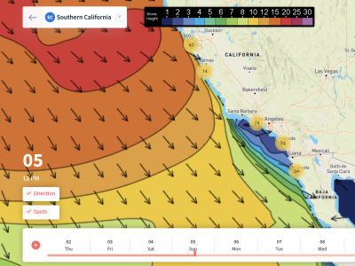
5.1.23 – Southern Hemisphere swell, which characterized most of the weekend, will back off almost completely by Monday morning. Northwest wind and ground swell quickly replaces the nice clean waves we had this weekend as a low-pressure system makes its way south along the west coast. With this system comes the largest waves we’ve seen in a while, along with wind, cooler air, and possibly even rain.
Winds from the northwest will really start to pick up further offshore Sunday night and Monday morning. By the afternoon those winds will have made it all the way to the coast giving everyone a strong onshore breeze for the second half of Monday and lasting through Tuesday morning. Beyond Tuesday, it looks like winds should calm down but possibly be replaced with rain.
A combo wind and ground swell will make for some huge waves Monday and Tuesday. The swell gradually builds throughout the day on Monday to where we may see 4-5 ft waves by the evening in San Diego! The swell continues to grow through Tuesday with 6 ft waves possible near the Mexican border. Most beaches won’t have waves that big but you should still find some decent sized surf along most west facing beaches.
From Tuesday night through Thursday the northwest swell really begins to die down and that’s also when rain enters the forecast. It’s a little early to tell precise timing but it appears as if Thursday will be our best chance of seeing rain. This could leave a window of opportunity to surf Wednesday especially towards the south but again, we won’t know anything for certain until we get closer to the event. 10-Day Forecast
Best Bets
- Tuesday evening should see the largest waves with 5 possibly even 6 ft near the Mexican border. Winds also stay light for this period.
- Wednesday morning also looks nice although waves will rapidly decline in size through the day. Still, this looks like a decent surf opportunity as wind remain light.
- Tuesday morning looks like the third best time to surf with pretty nice waves but winds may be troublesome.
MONDAY
The early morning hour start out pretty quiet but things rapidly change from there as northwest winds pick up. 2-3 ft swell looks likely across west facing beaches to start the morning off with 1 ft swell along south faces. Wind and ground swell rapidly build throughout the day as the low approaches SoCal. By noon, west facing beaches can expect waves to have grown by a foot since the morning. By the evening, waves will have grown even more to finish with 4 to maybe even 5 foot waves near San Diego.
Ventura county will have the next biggest waves at 3+ feet with all other west faces averaging 3 feet. South facing beaches miss out on the action this time around and continue with just 1 ft waves. These waves won’t be as clean as what the southern hemi swell brought but they should still be surfable if you can tolerate the wind. Periods average 12-13 seconds with onshore winds around 15 mph.
TUESDAY
The northwest swell continues to move in overnight to make for even larger waves by Tuesday morning. Waves continue growing through the day to finish with 4-6 ft waves near San Diego and 4+ ft waves around Ventura County/Oxnard. Our other west facing beaches including Venice/Hermosa Beaches should see 3 ft waves.
Winds also die down by around noon on Tuesday to make for what looks like the best day this week. The early morning starts out with 10 mph winds on average but we slowly see those speeds decrease through the day. By Tuesday afternoon, most of what reaches the shore should be a ground swell with 11+ second periods so this looks like a pretty good time to surf. It looks a little chilly though, highs stay in the upper-50s for Santa Barbara and low to mid-60s for Los Angeles southward.
WEDNESDAY
The swell starts to back down so waves will be noticeably smaller compared to that of Tuesday night. 3 ft waves return to Ventura County with 4 ft waves returning to San Diego. An accelerated decline in wave size is expected to occur through Wednesday as the day finishes with 2-3 ft waves near San Diego at the and 1-2 ft waves everywhere else.
Winds look like they should stay calm through the morning hours so that is definitely going to be the best time to surf. By the afternoon, winds pick up out of the southwest and rain begins to move in from the north. Temps look like they will be similar to that of Tuesday with highs in the 50s and 60s. The biggest difference is that Wednesday will have overcast skies compared to sunshine on Tuesday.
THURSDAY
By far, this appears to be the worst surf day of the forecast period. Rain looks increasingly likely across the entire area with temps staying cold, most places struggle to get to 60 degrees. A moderate onshore breeze is indicated by models with speeds around 10 mph out of the southwest.
Waves start out as the smallest all week for Thursday morning with 1-2 ft waves expected along all shorelines except San Diego where 3 ft waves are still possible. Waves gradually increase from the southwest through the day as winds continue from that direction. Unfortunately, the rain will prevent anyone from enjoying the surf for Thursday afternoon.