Overview
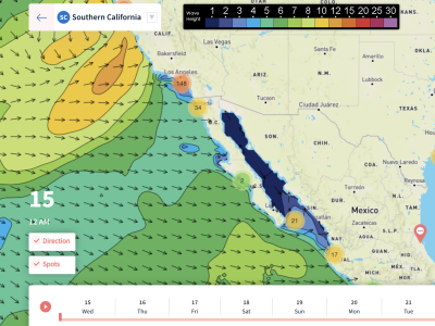
3/25/22 – 3/31/22: More opportunities on the way for fun surf as we wrap up the month of March. Both the North and the South Pacific will continue to help out, as we typically see this time of year. The main story this week will be a good-sized mid-period WNW swell peaking early in the week. This WNW swell will be coming from a local storm expected to form just off the coast of California, and even deliver some meaningful late March precipitation. Size from this swell is expected to peak later Monday the 28th and into Tuesday the 29th. The swell will continue to ease through the rest of the forecast, but still showing fun surf for a lot of breaks across the region. There is also going to be a little bit of Southern Hemisphere swell in the water starting Friday the 25th and into that weekend. Nothing special, but it will be enough to make those southerly exposed spots kind of fun.
The main story weather wise this week will be the storm system affecting the region on Monday the 28th. This will most likely be the season finale for our rainy season, despite it being such a dry year. The weekend should be pretty mild with mostly seasonal temperatures expected, and by late Sunday night the wind will begin to blow stronger out of the south before the rain enters the region. Monday will be when the region sees the majority of the rain, with expected rain totals at about an inch. Select areas could see more rainfall, and some could see less. Both Sunday and Monday look like difficult days to target as this storm system moves through the region. There may be some windows, but the wind will mostly be onshore. Conditions could clean up by Tuesday the 29th, but as of right now that morning is looking like it will be a bit jumbled with light onshore wind on it. The end of the forecast may see lighter morning conditions, with the possibility of seeing south wind on it. We’re entering that time of year in spring when conditions are a bit less favorable…
Best Bets
– Small but kind of fun south swell along with minor NW swell over the weekend.
– Good-sized WNW swell tops out Monday the 28th and Tuesday the 29th, but conditions are expected to be unfavorable as our storm system moves through the region.
– Some opportunity for the end of the forecast with continued NW swell, but conditions remain up in the air.
Day to Day Breakdown
Friday the 25th: 2-4 feet
A smaller day of surf as new south swell picks up and some NW swell hangs in there. There should be a few peaks to track down during the morning tide drop. Morning winds will be mostly light, followed by a light/moderate afternoon westerly seabreeze. Expect marine layer and fog most of the day.
Saturday the 26th: 2-4 feet
Similar size to Friday, with a bit more south swell as it tops out and a bit less NW swell. The morning tide drop should be the best window for most breaks. Morning winds should be relatively light, followed by a lighter onshore wind. More marine layer and fog is expected.
Sunday the 27th: 2-3 feet
A tiny bit smaller than Friday/Saturday as the mix of swells in the water drops off. The morning is the best bet, but the weather models have been showing onshore wind from the south already picking up ahead of the storm system. Deeper marine layer should move in too.
Monday the 28th: 4-6+ feet (largest late!)
A stormy day with lots of swell, wind, and rain. The good sized WNW swell quickly becomes the dominant swell in the water and is expected to show best size late in the day. The weather models have been bouncing around a lot of the timing of this system as it moves through, so exact timing of swell and wind is a bit uncertain. Don’t expect any super clean windows, but it will still be worth keeping an eye on local winds this day.
Tuesday the 29th: 4-6+ feet (standouts see larger sets)
Good-sized WNW swell holds good size early then slowly eases through the day. Winter breaks will see size at least a few feet bigger than listed above, especially for the morning. This day is definitely worth watching, as there is a possibility the morning may have a brief window. Things will definitely be jumbled overall, and by the afternoon a stronger west wind will get on it.
Wednesday the 30th: 3-4+ feet
WNW swell drops off in size and then holds fun size for most of the day. There may be just a tad of south swell in the water but may not play a role for most breaks. If the wind cooperates there could be a few decent corners to track down. Right now there’s a chance some south wind could be on it early.
Thursday the 31st: 3-4+ feet
Similar size to Wednesday as a new pair of swells show. A new mix of WNW groundswell and south swell is expected to be on the rise. Too early for wind specifics at the moment, but there is a chance they trend unfavorably.
Long Range Forecast
As we head into April, there is still more on the horizon to look forward to. More pulses from the North Pacific look probable, and the South Pacific continues its gradual wake up. Expect bigger rounds of Southern Hemisphere swell to start the first week of April (compared to March at least). After our single storm to end March, April is looking mostly dry. That will probably be our seasonal finale, but that doesn’t mean we can’t get a few showers here and there in the coming weeks. Also to note, this time of year the morning winds start to become a bit less favorable. More days of marine layer and south wind in the morning are ahead.
– Jax Richards @jax6street
If you’d like to receive these day by day forecasts every week, sign up for our newsletter