OVERVIEW (2/20 – 2/23): This weekend remained fairly calm for this most part just as we predicted. The weak NW ground swell that’s currently in place will continue through the day Monday and for the first half of the day Tuesday before some major changes take place further in the week. Before then, the weather should stay calm and pretty nice, similar to what we had this weekend. Tuesday afternoon and onwards is when things get interesting.
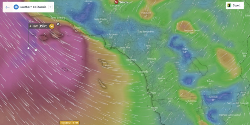
Right now, the semi-permanent North Pacific High is sitting in its usual position way off the California/Oregon coast. Models show that it should stay where its at over the next few weeks which may sound boring but this actually has some pretty significant implications to our weather here in SoCal. The high will steer a series of low-pressure systems around its center and bring wind, waves, and rain to our part of the coast. The next round of this kind of weather should begin Tuesday evening as a low is forced southward into SoCal.
The winds and surf stay weak for the first half of the day on Tuesday. In the afternoon, the winds will pick up from the west becoming progressively stronger from north to south. By nightfall, were looking at 15-20 mph winds nearshore with 45 mph winds further off the coast. This will create a pretty big wind swell across the region. Things don’t really improve by Wednesday morning, in fact, they worsen. We’re expecting 30+ mph onshore winds across the entire area on Wednesday making for some hazardous conditions. The weather will be cold and rainy too, making for a poor and dangerous surf day.
The wind swell will be huge on Wednesday with double overhead heights possible near San Diego. All west facing beaches will see at least 4 ft wind swell at the minimum from Tuesday afternoon until Wednesday afternoon. Finally, the winds will calm down by Wednesday night and with that, the wind swell should weaken significantly. Thursday will be a much calmer day with onshore winds averaging 10 mph with a 2-4 ft wind swell.
Subscribe to see the 10-Day Forecasts
Best Bets
- Any time of the day on Monday is going to be the best. The weather will be calm and sunny with a weak but decent ground swell from the NW.
- Tuesday morning should be calm across the area but winds will be strong by the afternoon. A weak NW ground swell will still be in place for the morning with light winds.
- After Tuesday morning the weather gets pretty nasty but the next best time to surf would likely be Thursday when winds calm down. It’s still expected to be cold and rainy at this point however.
MONDAY: Conditions are going to be calm on Monday. It will basically be a continuation of what we saw over the weekend with very light winds and weak ground swell from the northwest. San Diego will have the largest waves at 3-4 ft while everyone else will range from 1-2 ft. Winds will start out calm/light and variable for the morning but then a light onshore breeze should develop by the afternoon staying under 10 mph.
Periods will gradually get shorter and shorter throughout the day but will still stay within the range of 12-14 seconds throughout the day. High temps will be the warmest on Monday with afternoon temps ranging from the mid-60s for San Diego and Santa Barbara with LA expected to reach the low-70s. The sun will be out too so this should make for a great day for beginners/intermediate surfers before the weather gets too crazy later in the week.
TUESDAY: The morning will start out decently calm with winds staying light/variable nearshore until about 1 p.m. The strong winds will be located further offshore through most of the morning but by the afternoon, everyone will have a strong west wind. From San Diego to LA, there will be an onshore wind around 20 mph for the afternoon while areas to the north will have winds blowing parallel to the shore at speeds up to 35 mph near Ventura.
A dominant wind swell will develop throughout the day with max heights expected around nightfall. By 6 p.m. areas near and south of San Diego will have a 5-7 ft wind swell while all other west faces will have at least 4 ft waves. South faces will have 1-2 ft waves since winds will be blowing offshore. The northwest winds will blow in cooler air with clouds and possibly rain. Highs will be 5-7 degrees cooler than Monday with rain possible to the south.
WEDNESDAY: Hazardous conditions are expected to continue through most of the morning across the area. Only the most experienced surfers should attempt to ride these waves as we’re still looking at a 5-7 ft wind swell for San Diego and a 4-5 ft wind swell for Venice Beach and Ventura. Winds will be especially strong during the early morning with everyone experiencing northwest winds. West facing beaches will have 30+ mph sustained winds for a good part of the morning.
Winds will come down some by the afternoon though. And because of that, the wind swell will weaken throughout the day. It will still be gusty though, with 20+ mph winds expected around 5 p.m. for everyone except Santa Barbara where the higher terrain to the north will act as a shield. The wind swell will be 4-6 ft near San Diego and around 4 ft for Ventura for the afternoon hours. All other west faces will have waves between 3-4 ft. The overall weather on Wednesday will be cold with highs in the 50s and rain possible.
THURSDAY: Things will have calmed down significantly for Thursday morning. Instead of 30 mph winds we will have around 5 mph winds out of the west to start the morning. West facing beaches will see 2-3 ft waves as ground swell mixes in with a much weaker wind swell. San Diego will have slightly larger waves around 4 ft for the morning hours. Periods will be very short during this time frame with just 7 seconds expected for everyone except near San Diego where 12+ seconds are still expected.
By the afternoon winds will stay relatively constant compared to the morning with some areas seeing a slight pick-up in speeds. All around we expect an onshore breeze around or under 10 mph across SoCal. The swell will weaken progressively through the day with 2-3 ft waves expected for west facing beaches and 1-2 ft waves for south faces by the afternoon. The weather will be cold with highs in the 50s and rain is looking likely for everyone Thursday.