Overview
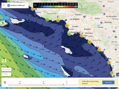
11/26/21-12/2/21 – Unfortunately another slower week of waves is expected for this week’s forecast. There should be a bit more swell in the water compared to last week’s flat spell though, and conditions will be mostly favorable each morning. Our focus remains on the North Pacific, as only minor southerly energy will be making it into SoCal for a few days this week. We will see small but rideable NW swell all week, with two NW swells pushing towards the fun zone range. The first small but fun NW swell will peak over the weekend of 27th/28th. The next swell should peak on December 1st, and will be similar in size to the first. Top winter spots will see the best size for these small to fun sized swells, but most breaks will still be pretty small.
Whether or not you like these warm and dry fall conditions as of late, it’s going to be another week of similar weather. All week will consist of temperatures above average for this time of year, with no precipitation in sight through the end of November. The good news at least will be that each morning will see favorable winds with calm conditions. The Santa Ana winds we saw Wednesday and into Thanksgiving day will weaken, and by Friday only select areas will see localized offshore flow. The ridge of high pressure that continues to dominate the west coast which is bringing us this warm fall is also blocking major storms that have the chance of delivering us any type of sizable WNW swell.
Best Bets
– The weekend of the 27th/28th will see a new NW swell with favorable conditions.
– The 1st of December will see fun waves as a mix of swells peaks.
– Warm and dry conditions continue through November, with light winds each morning.
Day to Day Breakdown
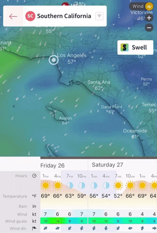
Friday the 26th: 2-3 feet
A pretty small day to start off the week’s forecast as only minor NW energy makes it in. There will still be some rideable waves for select winter spots, and some areas will see another morning of moderate offshore flow. This will be one of the warmest days in the week as well.
Saturday the 27th: 2-4 feet
Slightly bigger than Friday as new NW swell shows. Size will be a touch bigger in the afternoon, so that wouldn’t be a bad call to get on it then as winds look to stay light throughout the day. Could be a fun and nice day to get in the water.
Sunday the 28th: 2-4 feet
That new NW swell hangs in there, and continues to show fun waves for those winter breaks. The morning will see light winds, with possibly a touch of offshore flow in it. The afternoon will see a light to moderate onshore breeze from the west, so the morning is the call this day.
Monday the 29th: 2-3 feet
Less size in the water as NW swell eases. Things will be small, but if you want to get a surf in, get on it early as onshore flow picks up again through the afternoon.
Tuesday the 30th: 2-4 feet
Slightly bigger than Monday as new NW energy fills in. Size will be bigger through the afternoon as a little more energy shows then. Onshore wind will pick up, but it’s not looking too strong, so there could be a window towards the back half of the day.
Wednesday the 1st: 3-4 feet
One of the best days in the forecast. The NW swell tops out, and shows best size for the first half of the day. There will also be a slight bump in south swell, so there could be a few peaks for the combo breaks. Winds are looking favorable for the morning too.
Thursday the 2nd: 2-3 feet
Smaller again. Will probably be some leftover peaks as little combo of swells lingers. The morning winds should be favorable again, so that will probably be the best window. High tide early will slow things down.
Longe Range Forecast
Even though we’re seeing a little bit more activity in the North Pacific than we did last week, no major swells are on the horizon as of now. Models keep pushing back that possible pattern change that was forecasted for around the first few weeks of December. Things still look more favorable for swell production for the month of December as a whole.
November will end with no measurable precipitation for pretty much all of SoCal, and the beginning of December looks to continue that way. There still looks to be a better chance of precipitation towards the middle of December, but I wouldn’t be surprised to see models keep pushing things back like they have been lately.
– Jax Richards @jax6street
If you’d like to receive these day by day forecasts every week, sign up for our newsletter