All Orange County beaches are back open this week after the major oil spill that occurred off of Huntington Beach on October 2nd.
Overview
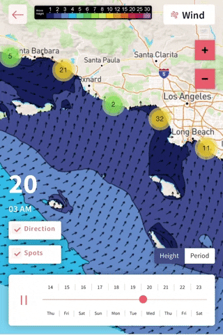
We have a pretty mellow week of surf ahead of us this week, but there will still be plenty of waves to track down throughout the forecast. Keep an eye out for tarballs that continue to make it to shore. Some of these areas may still be unsafe to enter the water, so continue keeping an eye out on your local water quality.
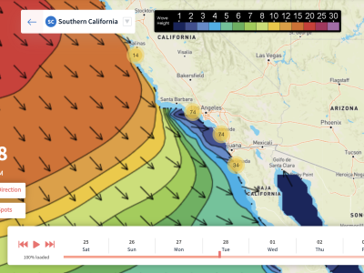
Continued Southern Hemisphere swell will show fun-sized waves for top breaks, with best size the first few days of the forecast. We’ll still have some small southerly energy lingering into the rest of the week as well. The North Pacific won’t be showing much size throughout the forecast, but towards the end of the week things will get a bit more interesting. Confidence is increasing that we’ll see the first fun-sized WNW groundswell of the year during the timeframe of Thursday the 21st. Details are still slightly uncertain, but the long range certainly looks promising!
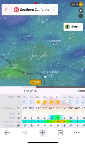
The start of the forecast will start off nice and warm as light offshore prevails Friday. Coastal areas could get into the 80’s this day. This will be the warmest day in the week as we’ll see a gradual cooling trend across the area through the workweek. Cloud cover will increase, but local winds will stay on the lighter side with clean conditions most mornings.
If you haven’t surfed since the oil spill, note that the water temps have dropped a few degrees into the low 60’s after last week’s blow through of west winds and cooler outside temperatures.
(Cooling trend after Friday) >
Best Bets
– Target south facing/combo breaks Friday/Saturday along with light offshore winds.
– Peaky and small midweek but still a few corners to track down.
– Fun-sized WNW groundswell peaks Thursday the 21st.
Day to Day Breakdown
Friday the 15th: 3-4 feet
One of the better days in the week to target. Locally fun-sized Southern Hemisphere swell will hold decent size most of the day, but gradually losing energy through the afternoon. There will be a tad of NW windswell mixing in, so there will be occasional peaks at the combo breaks. Morning conditions will be nice and clean with light to moderate offshore winds. Then winds will trend onshore around noon.
Saturday the 16th: 2-4 feet
A bit smaller than Friday, but another day of clean and peaky surf in store. Southern hemi continues to trend down, while minor NW windswell mixes in. Morning winds will be lightly offshore again, but not as offshore as Friday. A light west wind will eventually kick in late morning, but not getting too strong for the rest of the day.
Sunday the 17th: 2-3 feet
The downward trend continues as surf pretty much becomes leftovers of small south swell and minor NW windswell. Morning winds will be calm to slightly onshore as an incoming trough approaches the region. Afternoon onshores are looking a bit stronger than the past few days.
Monday the 18th: 2-3+ feet
Similar size to Sunday, with a touch more size for some combo breaks. South swell continues, along with a slight refresh of NW windswell. Morning winds look mostly clean followed by bumpier afternoon conditions.
Tuesday the 19th: 2-3+ feet
Peaky little combo continues. Mix of swells hang in there, but still pretty weak for most breaks. Morning high tide will slow things down too. Morning winds are looking light, with a small chance of seeing some south wind on it.
Wednesday the 20th: 2-3+ feet
Combo of swells slightly eases. If the models continue the way they are, we could see that new WNW groundswell fill in through the day, showing best size farther north. Not expecting anything major from this swell, but wintertime focal points could be pushing 4 feet or so on the sets. Winds are looking mostly light at this time.
Thursday the 21st: 2-4 feet
Possible WNW swell tops out. Wintertime breaks will be seeing the best size which is shown above. South swell eases and becomes secondary for most breaks. Could be a fun day of surf if the winds cooperate, and right now it’s looking mostly favorable.
– Jax Richards @jax6street
If you’d like to receive these day by day forecasts every week, sign up for our newsletter