Overview
2/25/22 – 3/3/22: Onshore flow and cold temperatures have mostly exited SoCal, with a more favorable pattern for local conditions and a little bit more surf expected for the region this week. One of the main swells on the way this week (late weekend and into workweek) is a long-period WNW swell that traveled across the entire North Pacific. This will result in a more selective and inconsistent swell for most breaks, but medium sized for those winter exposures. We’ll also have some smaller WNW energy through most of the week that will keep things rideable. There should be just enough Southern Hemi mixing in a few days this week at top breaks to make things peaky and to help out the combo breaks.
After a pretty cold couple of days, that recent low pressure system that brought some hail and low elevation snow has finally moved through the region. Temperatures are expected to warm back up to seasonal levels by the weekend. On Saturday the 26th, a weak to moderate Santa Ana wind event is expected, with morning offshore flow expected for much of the region. Into the workweek, the warming trend will continue as upper level high pressure builds into the region. Note that water temps have dropped a few degrees after last week’s onshore winds. Most of the region is now seeing water temps in the high 50s.
Best Bets
– Small combo of WNW and south swell over the weekend as well as favorable morning conditions.
– Long period WNW swell builds Sunday the 27th, and peaks for most breaks Monday the 28th.
– Size drops off during the workweek but remains fun as morning winds stay calm.

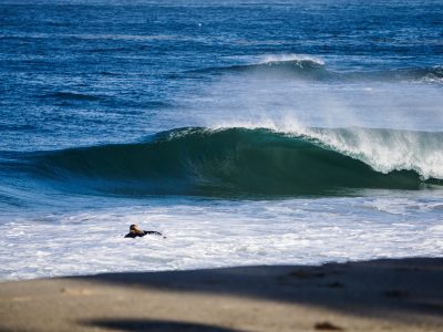
Frosty Winter Mornings | Courtesy @khph
Day to Day Breakdown
Friday the 25th: 1-3 feet
A pretty small day of surf as just a minor pulse of WNW and south swell show. Morning conditions will be favorable, so it could still be worth a surf. It will be another cold morning early, but not quite as bad as the last few days. Watch the midday low tide and afternoon onshore wind.
Saturday the 26th: 2-3+ feet
Size will be a tad bigger than Friday as WNW energy pulses up a bit more. There won’t be much south swell showing, so the WNW energy will be dominant. The morning will see offshore flow for much of the region, with some localized areas seeing stronger winds than others. The wind is expected to switch midday and remain onshore after that.
Sunday the 27th: 3-4+ feet
Our new but selective/inconsistent WNW swell builds all day. The biggest size will show later in the day, especially for the long-period winter focal points. Spots that can’t handle long-period WNW swells will be smaller than the numbers above, and top winter spots may see larger sets late. The morning will see clean and calm conditions, followed by a westerly seabreeze.
Monday the 28th: 3-4+ feet
One of the best days in the forecast. Fun-sized WNW swell tops out and should hold fairly steady all day. Just like Sunday, spots that can’t handle long-period WNW swells will be smaller, and top winter spots will be a few feet bigger than the numbers above. It will be another day of clean morning conditions and an afternoon onshore breeze. Watch the morning high tide.
Tuesday the 1st: 3-4+ feet
Continued WNW swell will result in more fun surf to start off March. The swell period is expected to drop a few seconds, so this means surf will be able to get into more breaks across the region. Some breaks could be better this day compared to Monday. Once again, mostly light morning winds are expected, so that will be the window to target. Just keep on eye on the deep morning tide, probably best to wait a few hours after the peak.
Wednesday the 2nd: 2-4 feet
Size will drop off a notch from Monday/Tuesday, but will remain fun for a lot of breaks throughout the region. Continued WNW swell will gradually lose steam, so best size will show in the morning. Try to find somewhere that can handle the high tide. As of right now, conditions are looking fairly clean.
Thursday the 3rd: 2-3+ feet
The gradual decline continues. Even though the surf will be smaller, there should be a few fun waves to track down here and there. Keeping an eye on conditions right now, there is a slight chance they may turn unfavorable.
Long Range Forecast
The North Pacific is still hanging in there. In fact, the swell on the way this week is a bit bigger than I thought we’d see through February, so that’s good news. I don’t think we’ll see anything bigger than what we’re seeing from this swell, but definitely more rideable to fun-sized surf from the NPAC in the near future.
We will probably see more short period NW swells in the coming months, which is typical for this time of year. We are also just around the corner from seeing more Southern Hemisphere swells, and some of the latest model runs have been showing potential in the coming weeks for rideable surf.
As we head into March, there still hasn’t been much promise for a big pattern change that includes precipitation. There have been some signs of potential, but as of right now the next few weeks are looking pretty dry.
– Jax Richards @jax6street
If you’d like to receive these day by day forecasts every week, sign up for our newsletter