Overview
4/1/22 – 4/7/22: Nothing too noteworthy to start off the month of April, but a fun spring mix of surf is expected to continue through this week’s forecast. There will be a few different pulses of NW swell in the water this week. One mid-period NW swell will peak early in the forecast over Friday April 1st. That energy will linger through the weekend staying rideable for top winter breaks. Then a shorter period NW swell mix will show during the start of the workweek. There should also be enough south swell in the water to break things up for the combo breaks through the weekend. Then a bigger Southern Hemisphere swell could begin to build in on Thursday the 7th to end the forecast. This swell will show better for the next forecast.
Spring is here, and that means more marine layer and south wind in the mornings. Expect a few of these mornings to come, while starting over the weekend. Fortunately most mornings still look to be manageable with just a slight southerly breeze and a light onshore wind. Some of the afternoons this week may stay light enough to get a surf in. Temperatures will be cool over the weekend influenced by our marine layer, and then through the workweek a gradual warming trend will take place. By the end of the forecast on Thursday the 7th, another early season heatwave looks likely with temperatures rising to well above average for April norms.
Best Bets
– Target Friday April 1st, as a fun little combo of NW and south swell shows along with relatively light morning winds.
– Short period NW swell mix shows through the workweek, but conditions not ideal.
– A possible day to target at the end of the forecast on Thursday the 7th as a mix of swells shows with better conditions.
Day to Day Breakdown
Friday the 1st: 3-4+ feet
The first day of April is looking like a fun day to target. The primary swell in the water will be the mid-period NW swell topping out. A smaller but still noticeable south swell will show as well, helping out the combo breaks. Morning winds should be pretty light, possibly a light onshore breeze on it for some areas. Just a weak onshore wind will be on it the rest of the day.
Saturday the 2nd: 2-4 feet
Could be another fun day of surf if the local winds cooperate. Right now weather models are showing south wind across much of the region to start off the day along with a deep marine layer, so it’s not looking great. The mix of NW and south swell holds to slightly eases through the day. Size should be a tad smaller than Friday.
Sunday the 3rd: 2-4 feet
Similar size as Saturday with more south wind and marine layer. If looking for a weekend surf, some spots could still be manageable or kind of fun. There will still be a little bit of NW swell in the water and some south swell hanging in there.
Monday the 4th: 2-4 feet
A new swell builds in on Monday. It will mainly be a short period NW swell mix showing small and broken up surf across the region. This day could be fun if the winds cooperate. Right now it’s looking lighter than the mornings compared to the weekend, but still slightly onshore.
Tuesday the 5th: 3-4+ feet
A slight increase in size from Monday as more NW swell mix shows. Breaks that handle the shorter period NW energy will be the call this day. A small south swell will be in the water too. Another day of light south wind is possible. The morning should see the cleanest conditions but the afternoon could stay clean for select breaks.
Wednesday the 6th: 3-4+ feet
NW swell mix should hold size in the morning, and then ease through the day. Exact timing of this swell mix is uncertain but expect more short period energy this day. Conditions may finally improve as warmer weather is expected.
Thursday the 7th: 2-4 feet
Possibly a fun day to target as conditions may finally trend favorable with offshore flow. There should be a little bit of NW energy leftover, while a new Southern Hemisphere swell builds in through the day. So there could be a few peaks to track down.
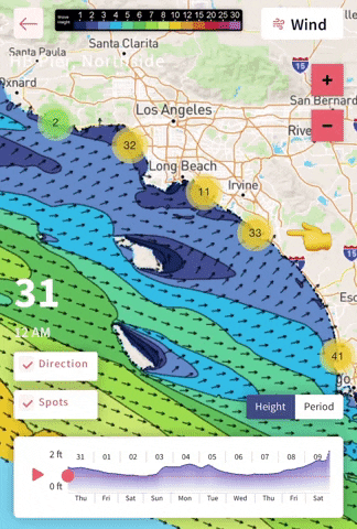
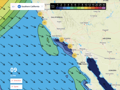
👆 *Tip: If you click on the dots along the shoreline, you can see the local surf height trend for specific spots. If you click on the spot name, you can see the timeline version as well.
Long Range Forecast
Things are definitely feeling like Spring. Conditions are becoming much more of a wild card with more south wind in the mornings.
The North Pacific is slowing down a bit now, but more localized short period swells are helping the cause. The South Pacific is waking up, sending small to medium sized rounds of Southern Hemi to SoCal. Models keep backing down on more sizable swells that looked possible for the end of March and early April. A larger round of Southern Hemi looks likely in the coming weeks.
– Jax Richards @jax6street