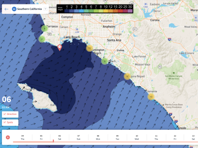
Overview
4/8/22 – 4/14/22: A much more typical spring week on the way compared to the record heat we’ve seen the past few days. No major swells expected to be in the water again this week, but definitely plenty of swell to be had if the conditions can somehow cooperate. We have a few locally decent sized NW windswells on the way this week, which will be the majority of the swell winter breaks receive. There is also one round of Southern Hemisphere swell in the water right now and building into Friday the 8th, while another similar-sized round is expected to fill in during the middle of the week. So overall, lots of different swells in the water with lots of peaks to be had at the beach breaks.
Unfortunately the conditions do not look to be in our favor this week. We’re expected to see multiple troughs dig into the region which will result in gusty NW winds in the outer waters, but locally south to southeast wind most mornings. There should be windows during late mornings and possibly a few afternoons where the winds could be light enough for a fun surf. As far as precipitation goes, not much is expected, just much cooler conditions and a deeper marine layer through the majority of the workweek. An update on local water temperatures: temps have slowly risen into the low 60s for most of SoCal.
Best Bets
– Friday the 8th will most likely be the best/cleanest day to target.
– Targeting the weekend, specifically Saturday, as a mix of south swell and localized short-period NW swell mix shows.
– More mix of swells all through the workweek, but conditions look problematic most days.
Day to Day Breakdown
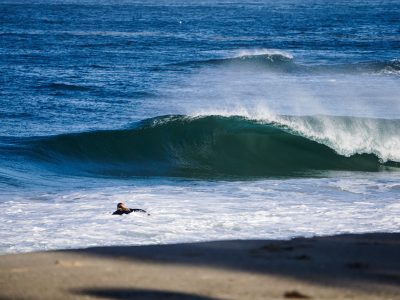
Friday the 8th: 3-4+ feet
A good day to target compared to all the other days in the week. The dominant swell in the water for most breaks will be the building Southern Hemisphere swell, which will show a bit better size towards the end of the day as it tops out. Some small NW swell will be mixing in. Favorable, clean morning conditions are expected, followed by a moderate westerly seabreeze. One more warm day expected for the coasts.
Saturday the 9th: 3-5 feet
Another fun day compared to the workweek ahead. The fun sized topped out south swell holds steady all day, while a new short-period NW swell mix picks up. There should be lots of peaks to be had across the region this day. Conditions will be worse than Friday, but still clean enough in the morning to get a surf in. A bit stronger onshore flow in the afternoon will put some texture on it.
Sunday the 10th: 3-5 feet
Pretty similar size as Saturday, but conditions trend even more unfavorable. The weekend south swell will begin to slowly ease, and NW swell mix will hang in there holding size through the day. A stronger south wind looks likely for the morning at around 5-8 knots. Probably not the best day to target, but the morning may be the lightest window.
Monday the 11th: 3-4+ feet
Even less south swell in the water, but shorter period NW swell maintains size to slightly eases. Unfortunately unfavorable morning conditions look to continue as a trough is expected to approach the region. The afternoon doesn’t look any better.
Tuesday the 12th: 3-5 feet
More short period NW swell expected, as steady NW winds off the coast look to continue. The period on this one looks even shorter than Sunday/Monday, so things will probably be messy out there especially if we see stronger onshore flow along with it. In the background a new Southern Hemi looks to start building in. Still not a great day to target due to poor conditions.
Wednesday the 13th: 3-4+ feet
Similar size again, with a tad less NW windswell and more south swell in the water. Right now weather models show conditions could improve some compared to the last few days, but still far from ideal. Probably a day worth watching though.
Thursday the 14th: 3-4+ feet
Even less NW swell in the water, but south swell continues and should become the dominant swell in the water. So this could be a fun day if the conditions improve. Right now they are looking better than the beginning of the workweek, but not ideal.
Long Range Forecast
Nothing too major to report for the long range this week. The South Pacific should continue to be somewhat active, and become more active as Spring progresses. Even though the broad North Pacific is slowing down, more NW windswells look likely in the coming weeks which is very typical for this time of year.
– Jax Richards @jax6street