Overview
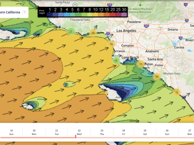
Hope everyone got some waves last week, because this week’s forecast is going to be slower. The good news is that warm weather and clean conditions are on the way. The swells in the water this week will be a few small pulses of Southern Hemi, and a bit of localized NW windswell through the 26th to the 28th.
Size throughout the forecast will be on the smaller side (2-3 feet), but there will still be some rideable waves to track down during the right windows.
A much more typical August week of weather is in store compared to last week. High pressure will bring a warming trend to SoCal for the back half of the work week. Through the weekend, the warmth will continue to linger across the region resulting in temperatures ranging from the mid-to-high 70s for the coastal areas.
Looking ahead past the weekend (end of August into September), weather models are hinting at a potential surge of monsoonal moisture moving into the region, influenced by a weakening tropical system down south out of our swell window. Confidence is very low at this point, but it will be something worth watching weather-wise. Our state could definitely use some rain right now, as drought conditions continue to worsen into our dry season.
Local water temperatures are running in the mid-to-high 60s at the moment, with some select locations pushing 70 degrees near San Diego. We should see these temps persist, to even a slow increase, as warm weather continues into the end of August.
Overall, it will be a nice week to get in the water if you don’t mind the small surf.
Best Bets
*Little combo swell Friday/Saturday with clean conditions
*Nice August weather returns
Day to Day Breakdown
Thursday the 26th: 2-3 feet
A mix of small Southern Hemi and a minor pulse of NW windswell. The morning will start off with a light west wind, picking up further into the afternoon. Better to get on it sooner than later this day.
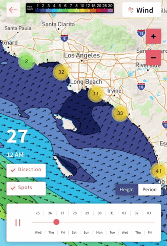
Friday the 27th: 2-3 feet
Nice little combo as small Southern Hemi energy hangs in there, and NW windswell pulses up a bit more. Morning winds will be calm, with glassy conditions expected. Afternoon winds won’t be as strong as Thursday, so don’t rule out an evening session.
Saturday the 28th: 2-3 feet
Continued energy from the South Pacific, but nothing bigger than 2-3 feet, even for the summer spots. A bit of NW windswell leftover from Friday, but that energy will fall off pretty quick. Conditions in the morning look favorable with glassy conditions. A west wind will get on it in the afternoon, stronger than Friday.
Sunday the 29th: 2-3 feet
Just minor energy from the South Pacific, no more NW windswell. The morning may start off with a little texture as west wind picks up through the day. Better to target a morning session if looking for a surf.
Monday the 30th: 1-3 feet
Pretty minimal day of surf. Leftovers of Southern Hemi will barely show rideable waves for top summer spots. Winds look light in the morning, followed by an afternoon seabreeze from the west.
Tuesday the 31st: 1-3 feet
Very similar to Monday. Small surf continues, probably a good day to bring out a longboard. The morning may start off with a light onshore wind, weather models still in a disagreement.
Wednesday the 1st: 1-3 feet
Another repeat of the last few days to kick off September. There may be a slight increase in NW windswell, but it’s not looking like much at this point. Morning winds could trend unfavorable, but details are uncertain.
– Jax Richards @jax6street
If you’d like to receive these day by day forecasts every week, sign up for our newsletter