3.31 – 4.2: Good news for this weekend as rain shuts off on Thursday leaving us dry, sunny, and warmer beginning Friday. Highs progressively get warmer through the weekend so by Sunday, we’ll be near 70 degrees. The weekend starts slightly cooler with Friday’s highs near 60 with partly cloudy skies and all-around pleasant weather.
3.31 – 4.2: Good news for this weekend as rain shuts off on Thursday leaving us dry, sunny, and warmer beginning Friday. Highs progressively get warmer through the weekend so by Sunday, we’ll be near 70 degrees. The weekend starts slightly cooler with Friday’s highs near 60 with partly cloudy skies and all-around pleasant weather.
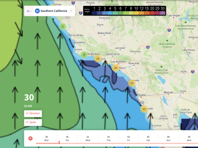
A glancing blow of Southern Hemi ground swell will make this weekends wave forecast a bit different from what we’ve seen over the recent past. The NW ground swell will back off on Friday in perfect timing for when the SH starts to move in. Waves won’t be huge, but we’ll see some surfable waves coming in from the southwest.
The SH ground swell is forecasted to continue for much of Saturday although waves will decrease in size throughout the day. Periods should stay nice with 14 second averages. By Sunday evening a return of northwest swell will move in and overwhelm the SH swell to where you will barely notice anything coming in from the south.
Winds should stay light through the weekend close to the shore while stronger winds from the northwest are expected further offshore. There may be times when the winds pick up onshore this weekend but for the most part we expect speeds to stay under 15 mph at the most. We could see a few areas experience offshore winds in the afternoon periods which would help warm air temps further.
Best Bets
-Friday morning will have the biggest waves although not the cleanest conditions. Waves will average 2-3 ft.
-Saturday will have a clean SH swell dominate with nice calm weather especially in the morning. Waves will be small though with 1-2 ft expected.
-Sunday will likely be the warmest day although waves will continue to decrease with just 1 ft waves likely.
FRIDAY MORNING
The biggest waves of the weekend occur Friday morning with 3-4 ft heights near San Diego and 2-3 ft heights elsewhere. Most of this will be due to a NW ground swell although some of the SH swell will begin to mix in from the southwest. Periods will range between 10 and 16 seconds with southwest facing beaches seeing closer to 16 seconds
Winds will either stay calm or light and variable with an offshore breeze developing in a few locations. This should help to warm our temps up rather quickly through the morning. Temps start out near 50 but with mostly sunny skies we will warm up nicely.
FRIDAY AFTERNOON
The northwest sell will diminish by the afternoon and eventually get replaced by the SH ground swell. As mentioned in the overview, the SH swell will be weak so waves are expected to decrease in size through the day on Friday. Almost all beaches will average 2 ft waves with 1 ft waves possible further to the north.
Periods remain largely the same from the morning with 11-16 second lengths so the overall surf conditions should stay fairly nice. This is especially true when considering the fact that temps warm to around 60 degrees and no rain is forecasted; winds stay under 10-15 mph.
SATURDAY MORNING
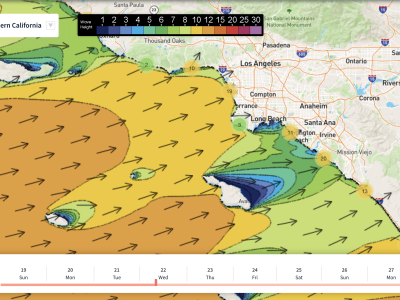
By Saturday, the northwest swell will have faded away almost entirely leaving just the SH swell to influence our beaches. Because of this, waves will stay extremely small for Saturday morning and really the rest of the weekend. 1-2 ft heights are expected with waves decreasing in size through the morning and afternoon.
Periods stay nice at least with 13 seconds anticipated across all beach fronts. The winds should stay calm near shore with speeds increasing from the northwest the further offshore you go. Temps will be very similar to Friday morning, maybe a degree or two warmer.
SATURDAY AFTERNOON
The nice weather continues for your Saturday afternoon with mid-60s expected for San Diego and Santa Barbara. LA could hit the low-70s. Winds may pick up a little bit for the afternoon in a few spots but again, most locations should see speeds stay under 10 mph.
The SH swell will continue to dominate nearshore with a another northwest swell beginning to pick up way far out in the Pacific. Waves will average 1-2 ft across all beach faces with periods averaging 13 to 14 seconds.
SUNDAY MORNING
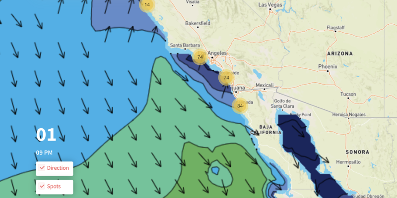
Waves continue to decrease in size overnight and by Sunday morning we expect all beaches to see just 1 ft waves. Periods continue to remain fairly nice with about 11-12 seconds anticipated up and down the coast. Waves will come in from the Southwest as the SH swell continues to dominate with essentially no NW swell.
Overnight temps continue to warm up so by Sunday morning almost everyone will already be above 50 degrees. Sunny skies are anticipated with no rain in the forecast. Winds remain light and variable nearshore with NW winds continuing offshore.
SUNDAY AFTERNOON
Most of the afternoon will stay calm but late in the evening, close to sundown, we may see winds pick up out of the northwest. This will create a dominant wind swell that should be prevalent by Monday morning. Most of your Sunday will stay calm and similar to the rest of the weekend.
This should be our warmest day with highs near 70 with sunny skies and no rain. Winds will stay light and variable until very late in the evening. The swell will average 1ft out of the southwest while offshore waves begin to increase throughout the day from the NW.