Overview
Fall is officially here. September to December is undoubtedly the best time of year to be a surfer on the West Coast, especially in SoCal. The South Pacific remains active, the North Pacific awakens from its summertime slumber, and the tropics can sometimes deliver their best swell of the year before it shuts down through November. And… Arguably the best part about these few months is that local conditions almost always align with pumping swell at some point in the season.
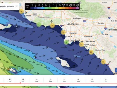
Although nothing too major on the way this week, we certainly have a little taste of fall on the way. We have both south swell and northwest swell expected throughout this week’s forecast. The south swell will be the biggest through the weekend and into next week, while a few small pulses of northwest swell will be running at the same time. This will result in some peaky days of surf throughout the forecast for breaks that can receive both the southerly and northwesterly energy.
Not quite an ideal week of fall conditions lining up, but certainly clean enough for some good sessions to be had, especially in the mornings. Most of these mornings will start off pretty clean with calm conditions, but there is a chance of a few days starting off with a minor texture. Most afternoons will consist of a typical westerly seabreeze, with a few days looking light enough for a somewhat clean evening session.
Looks like we’re going to end September with cooler than normal conditions for most of the region, with no heat waves expected through the end of the month. Local water temps tried to make a comeback last week, but most spots didn’t get over the high 60s. Expect our water temps to drop to around the low 60s into this week. As we get deeper into fall, the chances of seeing anything a lot warmer begins to decrease more quickly.
Subscribe to see the 10 Day Forecast
Best Bets
– Wintertime spots are beginning to come into play as we head into fall.
– Friday to Monday is looking like the best timeframe as combo of swells peak.
– Most mornings will have clean conditions, so target that over the afternoons.
A bit more south and northwest in the water, so top combo breaks could be pretty fun (Friday) – See the 10 Day Forecast
Day to Day Breakdown
Thursday the 23rd: 2-3 feet
One of the smallest days of the week. A fun little combo of south swell and minor northwest energy, along with a favorable morning tide push. Morning conditions will be fairly clean, so this day could still be a day to target. Onshore wind should pick up rather quickly through the day, and by the afternoon most spots will be blown out.
Friday the 24th: 2-4 feet
A better day to target compared to Thursday. A bit more south and northwest in the water, so top combo breaks could be pretty fun through that mid-morning tide push. Morning winds should be more favorable than Thursday, followed by lighter winds in the afternoon.
Saturday the 25th: 2-4 feet
South swell continues through the day, as the northwest energy drops off a bit. There should still be a few corners to track down at top breaks, but summertime spots will see the most size. Morning winds are pretty light, followed by a more typical westerly seabreeze. Target the morning for the best window of the day.
Sunday the 26th: 3-4 feet
Slightly bigger than Saturday as a fresh south swell builds in through the day. Another pulse of northwest swell is expected too, and should show towards the end of the day. Best bets this day is to target the summer/combo breaks in the morning as mostly clean conditions are expected. Afternoon onshores look to pick up as slightly more swell fills in from the south and northwest.
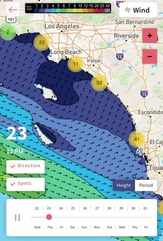
Monday the 27th: 3-5 feet
Biggest day in the forecast. Should be the best day to target too if those morning conditions can cooperate. Swells in the water will be the topped out south swell and holding pulse of small northwest swell. Note, this northwest energy is looking pretty selective. Only those top wintertime breaks will see fun size from this pulse, as most breaks only see minor energy. That being said, there should still be some occasional good corners to track down with this combo of swells running.
Tuesday the 28th: 3-4 feet
A bit smaller than Monday, but still a fun combo of swells in the water. The southerly energy is looking like it’ll be the dominant of the two swells for most breaks, but there will still be some peaks to track down across the region. Watching the morning winds, may trend slightly unfavorable, but too far out to say right now.
Wednesday the 29th: 3-4 feet
Still a small little combo out there as the southerly energy sticks around and minor northwest groundswell lingers. We may see an upstick in localized northwest wind swell, but at this point confidence is pretty low on details. We could see more size than listed above if the models continue the way they are right now. Could be fun if winds cooperate.
– Jax Richards @jax6street
If you’d like to receive these day by day forecasts every week, sign up for our newsletter