Overview
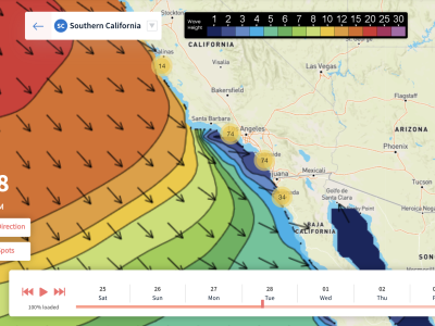
The South Pacific continued to push out decent sized storms last week which means more Southern Hemisphere energy is on the way. The medium sized south swell that built in through this past weekend will keep showing fun waves into the first half of the workweek. We’ll see another pulse of south for the end of the weekend which will be a few feet smaller than the first. There may be enough NW swell in the water later in the forecast to break things up, but that energy on its own will be very small.
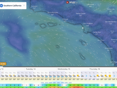
Conditions wise, the mornings will see the lightest winds as usual, followed by a westerly sea breeze for most afternoons. There will also still be some marine layer lingering at the coast a few days in the week which is pretty typical for this time of year. Later Tuesday into Wednesday, SoCal will see an increase in cloud cover in the form of subtropical mid to high level clouds coming from the southeast. There may even be enough moisture for a shower or two across the region, with a very small chance of thunderstorms Wednesday for areas further south.
Best Bets
-Target the beginning of the forecast for larger surf.
-Also target the mornings, as most afternoons look to have a westerly sea breeze.
Day to day breakdown (June 22nd – 28th)
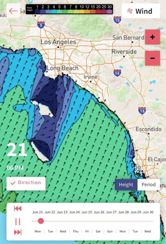
Tuesday the 22nd: 3-5+ feet
Biggest day of the forecast. The medium sized south swell will hold steady all day, showing best size for the south facing breaks as not much NW swell mixes in. A light west wind will already be on it in the morning, so the best bet will be to get on it sooner than later before things get windier in the afternoon.
Wednesday the 23rd: 3-5 feet (largest early)
The south swell begins to slowly wind down, but will still show pretty fun waves at those southerly focal points. The morning winds again look lightly onshore, so it’ll be better to get on it earlier. We’ll see that subtropical moisture move into the area bringing the chance of showers, so there is a slight possibility this could variablize the local winds at times, but there is low confidence on that. Could be worth watching.
Thursday the 24th: 3-4+ feet
Slightly smaller than Wednesday as the old south swell bottoms out. The new south will be able to maintain wave heights in that 3-4 foot range for the southerly focal points as it builds in. Morning winds will again be lightly onshore, so it’s another day to get on it sooner than later because of the afternoon onshores.
Friday the 25th: 3-4+ feet
South swell holds all day, and morning winds look a bit better than earlier in the week. The morning tide push will be the best window after it comes off a super drained tide early in the morning.
Saturday the 26th: 3-4+ feet
The run of fun south swell continues. Holding southern hemi along with a slight bump in NW swell, possibly enough to break up the dominant southerly energy for some peaks. The morning winds look lightly onshore, but cleaner than earlier in the week. The afternoon winds look lighter than the weekdays as well. Watch the drained tide early.
Sunday the 27th: 3-4 feet
The mix of swells eases slightly, but there will still be rideable waves to track down across the region. The winds may trend stronger onshore for the morning, but it could still be manageable. Watch the drained tide early again.
Monday the 28th: 2-3 feet
The southerly energy bottoms out along with minor leftover NW swell. The late morning tide push will be the call if the winds can stay light enough through the day.
– Jax Richards @jax6street
If you’d like to receive these day by day forecasts every week, sign up for our newsletter